Walk #407: Barras to Aberffraw
 |
 |
|
General Data
| Date Walked | 07/04/2003 |
| County | Anglesey |
| Start Location | Barras |
| End Location | Aberffraw |
| Start time | 10.30 |
| End time | 17.23 |
| Distance | 18.3 miles |
| Description | This was quite a nice little walk, although it could certainly be much better. It is very varied, with footpath, beach and road walking all featuring. |
| Pack | Today I carried my 30-litre Karrimor HotRock rucksack, which was filled with my packed lunch, waterproof leggings, water bottle and a couple of spare shirts, together with the usual assortment of odds and ends. |
| Condition | I feel absolutely fine after this walk, and I have no major problems to report. I am slightly fatigued, although less than I was after yesterday's walk. I am quite pleased about my condition, as I tried to walk quite fast for some of today, and have not suffered from it. |
| Weather | I was expecting today to be sunny (a result of the great weather I have experienced for the last month), but my expectations were dashed. It was cloudy all day, without much wind to help try to blow it away. This morning was bitterly cold and it took me a while to warm up, and I had unfortunately left my gloves at home. It also tried to rain for most of the day, although the drizzle never got hard enough to force me to put my coat on. |
| OS map | Landranger number 114 (Anglesey) |
 |
 |
|
 |
 |
|
Map of the walk
Maps courtesy of Google Maps. Route for indicative purposes only, and may have been plotted after the walk. Please let me have comments on what you think of this new format. For a detailed table of timings for this walk, please see the table file.
Notes
I had a very late start today, as I spent some time doing a little work on my computer whilst we had mains power. Sam stayed at the campsite, and my mum and dad drove me back down the island to Barras to drop me off. The initial section of the walk was fairly boring and nothing to really write home about; I have been told that Anglesey is beautiful, but if it is then the section of coast along the Menai Straits is definitely an exception.
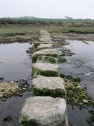
The path along the eastern bank of the Afon Braint was very boggy, and my feet got wet when my trainers sank through the overlying grass to the bog below. I can imagine that in wet weather this path would be quite wet indeed, and so boots should really be worn for this stretch. The river is crossed by a series of stepping sttones, and as I walked alongside the river I was unsure about whether I could cross it at this state of the tide. When I reached the stone, however, I had nothing to worry about; when I reached the stepping-stones I found that they were more like stepping boulders. They were about three feet square, and about the same height from the bottom of the river, which was low at this point. I could easily stride across these stones, aside from one that was slightly out of position, and I had to jump across this gap. A little further on I walked down a path leading along the eastern edge of Newborough Forest, and as I headed towards the beach I passed a woman who was walking her dog. Just as I was passing the dog it emerges from the undergrowth with a rabbit in its mouth; the rabbit was kicking its legs feebly. It was quite a sad sight, although looking at he dog I think that the rabbit must have been sick for the dog to catch it.
I was unsure about whether or not I was going to walk down to the end of Llanddwyn Island. When I reached the throat of the island it looked as though it might be quite a nice little walk, and so I decided to do it. There are large areas of pillow lavas, an the majority of the island is covered in sand which makes for some lovely little views, especially a Snowdonia was visible in the background. The island itself is quite interesting - it has a couple of crosses on it, and the remains of the church of St Dwynwen and an old lighthouse. The island is know as Lover's Island, and I must admit that even with overcast skies I fell in love with it - if the sun was shining then it would be even better.
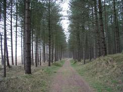
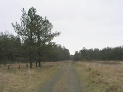
Earlier this morning I phoned up BBC Radio Cambridge to arrange a radio interview. They said that they would phone me back at twenty to three, but as that time approached I was walking along the path through Newborough Forest and I realised that I had no mobile phone reception. I had twenty minutes to go before the interview, and so I sped up and waked at four miles an hour along the good tracks through the forest (this is about as fast as I can walk and keep it up for a sustained period). Fortunately I got reception with about five minutes to spare, although I got no call at the allocated time. I continued at the fast pace until I reached Malltraeth as I was quite enjoying it, and near the end of the walk I got a phone call from the radio station apologising for not phoning and we rearranged the interview for tomorrow. The walk through Newborough Forest itself was quite nice, and I enjoyed walking through the trees, listening to the unmistakable sound of Woodpeckers as I walked. If it had been a sunny day it would have been absolutely superb, but I suppose that every day cannot be sunny.
Directions
This walk mostly follows the Anglesey Coastal Path, a new path being created around the island. There are some laminated map sheets available from local Tourist Information offices, and there will also be a guidebook released in a few months time. There are gaps in the path that remain to be filled, and new permissive sections of footpath have been created. I found the signage on these new stretches to be inadequate or even inaccurate; then again, it is very much work in progress. I found it best to use the new route as a guide and create my own route based on it, in time this situation should improve.
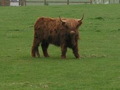
It starts off at the road in Barras, on the northern bank of the Menai Straits. Head southwestwards along the road past the Farm Park until the road ends at an old pier at the Mermaid Inn. Pass the buildings and then walk southwestwards for a few hundred yards along the foreshore until the cliffs on the right reduce in height, and then take a footpath that leads off to the right across fields to the farm at Cae Mawr.
At Cae Mawr join a track that heads southwestwards for a few hundred yards until it meets a public road. Turn right to head northwestwards along this road, and after about a kilometre turn left down a footpath for a short distance until it meets a track. Turn right up this track for a couple of hundred yards as it passes through a farmyard at Tan-twr and ends at a road. Turn right along this road and almost immediately turn left down another footpath.
When this footpath reaches the Cae'r-llechau farm turn right through the farmyard and then left down a track that heads northwestwards before ending at a stream by a boggy area of land. Turn left to walk beside the southern bank of the stream until it meets the flood bank of the Afon Braint. Cross the flood bank and continue on alongside the river until a ruined building is reached on the left. A few yards beyond the building there are some stepping-stones leading across the river.
Cross the Afon Braint using the stepping-stones and then head northwestwards along the track on the other side for about a kilometre until it ends at the A4080 road. Turn left along the A4080 road and when it reaches a roundabout continue straight on down a minor road that ends at a car park at Llyn Rhos-ddu. From the car park a track continues straight on, skirting the edge of the Newborough Warren sand dunes. The path winds around slightly before joining the southeastern side of Newborough Forest until the beach is met.
At the beach turn right and head westwards along it towards Llanddwyn Island. When the throat of the island is reached turn left and walk south across the island to the southern point. There are many tracks around the little island, so make your own way around them. At the southern point turn back and head north towards the throat of the island before plunging over the dunes and into the forest. A little way into the forest a broad track is reached.
Follow this track as it skirts the edge of the forest in a rough northerly direction. After about a mile and a half it emerges from the forest and starts to enter a boggy area; here a footpath leads off to the right, keeping to firmer ground before rejoining the track. When the track ends at a T-junction with another track turn left to head northeastwards along this track through the forest until it ends at a T-junction with the A4080 road.
Turn left along the A4080 road and when a car park is reached take a cycle path that leads off to the left along a flood bank called The Cob for about a mile. At the northern end of the flood bank rejoin the A4080 road at the sluices and turn left to walk uphill into Malltreath.
In the village turn left along a footpath that heads along the northern edge of Malltraeth Sands before heading inland and crossing a road. This part of the path is well waymarked, and it eventually emerges at a road near grid reference SH399683. At the road turn right and head uphill along a road until it ends at a bend in the A4080 road.
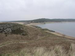
At the bend turn left along another minor road that heads in a roughly southwesterly direction before curving to the right to reach the chapel at Llwynysgaw. Continue on along the road as it winds around before eventually descending down to the southeastern edge of the Tywyn Aberffraw sand dunes. Here you have a choice; you can either follow a footpath through the sand dunes as I did or you can continue along the road into Abberffraw.
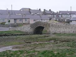
If you choose to the former then follow the obvious path through the dunes until the beach at Traeth Mawr is reached. Turn right along the beach until the Afon Ffraw is reached, and then turn right to walk back along the river through the dunes until the packhorse bridge is reached in Abberffraw, where this walk ends.
Distances
| From | To | Distance (m) | Ascent (ft) | Descent (ft) |
|---|---|---|---|---|
| Barras | Llanddwyn Island | 8.2 | 361 | 358 |
| Llanddwyn Island | Aberffraw | 10.1 | 525 | 528 |
This makes a total distance of 18.3 miles, with 886 feet of ascent and 886 feet of descent.
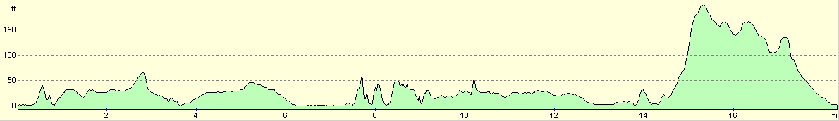
For more information on profiles, ascents and descents, see this page
Accommodation
We parked Mervan beside the little packhorse bridge immediately to the east of the village of Aberffraw. This was quite convenient for the local pub and the other facilities, although we did not really need to use them.
Disclaimer
Please note that I take no responsibility for anything that may happen when following these directions. If you intend to follow this route, then please use the relevant maps and check the route out before you go out. As always when walking, use common sense and you should be fine.
If you find any information on any of these routes that is inaccurate, or you wish to add anything, then please email me.
All images on this site are © of the author. Any reproduction, retransmissions, or republication of all or part of any document found on this site is expressly prohibited, unless the author has explicitly granted its prior written consent to so reproduce, retransmit, or republish the material. All other rights reserved.
Although this site includes links providing convenient direct access to other Internet sites, I do not endorse, approve, certify or make warranties or representations as to the accuracy of the information on these sites.
And finally, enjoy your walking!
This walk was mentioned in the following routes:
| My walk around the coastline of Britain |
Nearby walks
| # | Title | Walk length (miles) |
|---|---|---|
| 404 | Clynnog Fawr to Snowdon Ranger | 22.8 |
| 405 | Snowdon Ranger to Caernarfon via Snowdon | 16.2 |
| 406 | Caernarfon to Barras | 17.1 |
|
|

|