Walk #404: Clynnog Fawr to Snowdon Ranger
 |
 |
|
General Data
| Date Walked | 04/04/2003 |
| County | Gwynedd |
| Start Location | Clynnog Fawr |
| End Location | Snowdon Ranger |
| Start time | 09.15 |
| End time | 17.39 |
| Distance | 22.8 miles |
| Description | This was a long road walk, but despite this I quite enjoyed it despite the length and traffic. |
| Pack | Today I carried my 30-litre Karrimor HotRock rucksack, which was filled with my packed lunch, waterproof leggings, water bottle and a couple of spare shirts, together with the usual assortment of odds and ends. |
| Condition | I feel absolutely fine after this walk, and I have no significant problems to report. My ankles and knees are both fine, and for the first time in a couple of days I did not wear the brace on my left knee. |
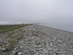
| Weather | T day started off slightly foggy, but this soon lifted and was replaced with low cloud and a little wind. As the day went on the weather slowly improved, until last thing, when the weather was sunny with only scattered cloud around the tops of the mountains. There was no sign of any rain, of which I am thankful. |
| OS map | Landranger number 115 (Snowdon & surrounding area) |
 |
 |
|
 |
 |
|
Map of the walk
Maps courtesy of Google Maps. Route for indicative purposes only, and may have been plotted after the walk. Please let me have comments on what you think of this new format. For a detailed table of timings for this walk, please see the table file.
Notes
The initial part of this walk into Caernarfon was fairly uninteresting, as most of it was a long plod along roads. There were a couple of interesting points, however; at Caernarfon airport there I a little air museum that I was tempted to enter, and I had a quick look around the planes outside it. The rest of the walk towards the castle at Caernarfon was fairly bland and uninteresting, aside from a 15 minute chat I had with a couple who were having a rest from a bike ride. I chatted to them about all sorts of things, including the walk, and I realised that today I was in need of social interaction.
There is a bridge to the southwest of Caernarfon that can be used to cross the Afon Seiont, and this saves over a miles walk up and down the river. The bridge is a swing bridge and is only open to the public at certain hours (generally during the hours of daylight), and gives access to the castle. It had been my intention to use this bridge, but unfortunately I got told by a couple of cyclists that I met that the bridge was closed to the public until it is repaired, and so when I reached the bridge it was swung back against the riverbank. I did not mind this too much, as I quite enjoyed the walk up and down the river, although it is hardly a classic walk.
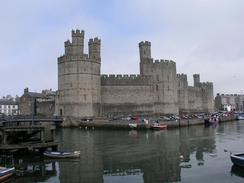
Caernarfon is a lovely town, and is dominated by the caste, construction of which started in 1283 by Edward I after the death of Llewelyn the Last, and it took forty years and £19,000 to complete. The city walls are virtually intact aside from one gap to allow a road through - the so-called 'Hole in the wall' street. Sam had parked Mervan by the new Welsh Highland Railway station in Caernarfon, This railway line used to run between Caernarfon and Porthmadog, where it connected with the Ffestiniog Railway before shutting in the 1930's. It is being rebuilt at great speed, and will be running as far as Snowdon Ranger later this year. As I walked along the A4085 I could see much of this construction work, and much of the trackwork has already been laid, although a few of the bridges are still incomplete or missing.
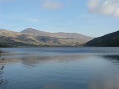
I had been slightly concerned about the walk along the A4085 from Caernarfon to Snowdon Ranger, as it involved a long walk along a main road. Fortunately I need not have bothered, as none of the bends in the road were difficult and the traffic was relatively light, although in the summer season I can imagine that it could be much busier. As I walked along the road view of Snowdonia slowly unfolded, until eventually I could make out the cafe on top of Snowdon, my target for tomorrow. I met Sam in the car park at Snowdon Ranger, and we immediately set off for an hour's drive to the campsite that my sister and her family were staying at.
Tomorrow promises to be quite an unusual day, as I have now diverted away from the coast and I am going to be climbing up Snowdon via the Snowdon Ranger path and then descending down to Llanberis along the Llanberis path, which should make quite an interesting circular walk. Sam is going to be taking the train as far up as it is going at this time of the year (probably the halfway station) and walk up to the summit to meet me. We can then walk down the mountain together, and if I feel like it then I will walk further from Llanberis back towards Caernarfon. I am very much looking forward to this walk, and it will make a nice change to have a walk up a mountain instead of one along the coastline.
Directions
This walk starts off by the church in the village of Clynoog Fawr. From the church walk northeastwards along the A499 road for about five miles, passing through the village of Pontllyfni and crossing the Afon Liffon before a road leads off to the left, leading towards Dinas Dinlle. Walk along this road into Dinas Dinlle, where it meets the coast and then skirts it northwards for a mile into Morfa Dinlle. In Morfa Dinlle follow the road as it turns sharply to the right and heads eastwards past the airfield until it ends near a caravan park at Morfa Lodge.
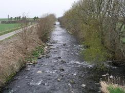
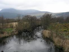
When the road ends continue straight on for a short distance along a track until it ends at the western side of Foryd Bay. Climb up onto the flood bank and turn right to follow a footpath southeastwards along the side of the bay. When a footbridge over the Afon Rhyd is reached cross the bridge and follow a footpath on the other side until it ends at a road.
At this road turn left and follow it for a couple of hundred yards until it curves to the right. At the bend turn left along another road that meets the southern edge of Foryd Bay before curving to the right. Shortly after this bend turn left along a footpath that follows a track past the farm at Foryd. When the track ends continue on along the footpath as it skirts the southern bank of the Afon Gwyrfai until it becomes another track that goes through a farmyard and ends at a road. At the road turn left to cross the Afon Gwyrai on a bridge and follow this road for a couple of hundred yards uphill.
Take the first road to the left and follow this road for a mile as it heads westwards back towards the eastern bank of Foryd Bay. When it reaches the bay it turns sharply to the right to follow the side of the bay northeastwards for a couple of miles until it reaches the Afon Seiont. There is a swing bridge here that can be used to cross over the river into Caernarfon; if this bridge is not accessible then follow the road around and down the southern side of the river until it reaches the A487 road. At the A487 turn left to cross over the river and then take the first road to the left, which heads northwards into Caernarfon and the other side of the swing bridge.
In Caernarfon turn right before the castle and head up into the main part of the town. Head eastwards out of the town, heading for the A4085 road. Once this road has been found, follow it for over seven miles until Snowdon Ranger is reached, where this walk ends. The initial stretch of this road has a pavement beside it, but when this ends aside from a few other isolated stretches there are not any more, but the road was quiet enough when I walked along it.
Distances
| From | To | Distance (m) | Ascent (ft) | Descent (ft) |
|---|---|---|---|---|
| Clynnog Fawr | Morfa Dinlle | 6.4 | 151 | 249 |
| Morfa Dinlle | Caernarfon | 8.5 | 381 | 358 |
| Caernarfon | Snowdon Ranger | 7.9 | 909 | 443 |
This makes a total distance of 22.8 miles, with 1441 feet of ascent and 1050 feet of descent.
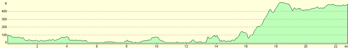
For more information on profiles, ascents and descents, see this page
Accommodation
We parked Mervan at the Bodnant Caravan Park, Bodnant, Nebo Road, Llanrwst, Conwy LL26 0SD. This site was absolutely excellent, and cost us nine pounds twenty-five pence for the night. Unfortunately it is rather far from the coast, and we only travelled this far to see my sister. They can be contacted on (01492) 6540248 or at www.bodnant-caravan-park.co.uk.
Disclaimer
Please note that I take no responsibility for anything that may happen when following these directions. If you intend to follow this route, then please use the relevant maps and check the route out before you go out. As always when walking, use common sense and you should be fine.
If you find any information on any of these routes that is inaccurate, or you wish to add anything, then please email me.
All images on this site are © of the author. Any reproduction, retransmissions, or republication of all or part of any document found on this site is expressly prohibited, unless the author has explicitly granted its prior written consent to so reproduce, retransmit, or republish the material. All other rights reserved.
Although this site includes links providing convenient direct access to other Internet sites, I do not endorse, approve, certify or make warranties or representations as to the accuracy of the information on these sites.
And finally, enjoy your walking!
This walk was mentioned in the following routes:
| My walk around the coastline of Britain |
Nearby walks
| # | Title | Walk length (miles) |
|---|---|---|
| 403 | Tudweiliog to Clynnog Fawr | 19.5 |
| 405 | Snowdon Ranger to Caernarfon via Snowdon | 16.2 |
| 406 | Caernarfon to Barras | 17.1 |
|
|

|