Walk #358: Hartland Quay to Buck's Mills
 |
 |
|
General Data
| Date Walked | 16/02/2003 |
| County | Devon |
| Start Location | Hartland Quay |
| End Location | Buck's Mills |
| Start time | 09.00 |
| End time | 15.15 |
| Distance | 14.2 miles |
| Description | This walk was a fairly enjoyable little stroll, heading northwards from Hartland Quay to Hartland Point, and then eastwards past the lovely village of Clovelly to Bucks Mills. |
| Pack | Today I carried my 30-litre Karrimor HotRock rucksack, which was filled with my packed lunch, waterproof leggings, water bottle and a couple of spare shirts, together with the usual assortment of odds and ends. |
| Condition | I felt radically different to yesterday, when I felt like a hill of any size would not stop me. Today my legs felt leaden and I had little (if any) energy, whilst later on in the walk I began to feel light-headed. Aside from this I had no real major problems with my knees or my ankle, for which I am glad. |
| Weather | The weather today started off exceptionally cold, although the frost was not as heavy on the ground as it had been yesterday. There was also more cloud in the sky, although the day was mostly sunny. Again the skies were hazy, obscuring any views that I may have been able to get of Lundy Island. |
| OS map | Landranger number 190 (Bude, Clovelly & surrounding area) |
 |
 |
|
 |
 |
|
Map of the walk
Maps courtesy of Google Maps. Route for indicative purposes only, and may have been plotted after the walk. Please let me have comments on what you think of this new format. For a detailed table of timings for this walk, please see the table file.
 |
Notes
This should have been an enjoyable walk with some lovely views, and I should have been on a high after yesterday, but sadly neither of these were the case. This was mainly due to the fact that I was feeling extremely grotty all day, and the first two and a half miles to Hartland Point took me much longer than it should have done. My legs felt extremely leaden, and I actually found some reasonably easy ascents hard, and the descents even harder. Later on in the walk I started to feel slightly light headed and nauseous, and of course this made the walk even harder. I do not know what cased all of this, but I can only assume that I tired myself out more yesterday than I had been expecting and that I did not get enough sleep last night. Whatever the reasons may have been, this thoroughly spoilt today's walk and made it into a chore rather than the pleasure that it should have been. I can only hope that I do not continue to feel like this tomorrow, as it really affected the distance that I walked.
I set off later than usual today, as I created a CD that could be sent to Terry so that he could update the website with all of the latest information. Each of these updates takes me a considerable time to do, and even after I had prepared most of the data last night it was still nine before we got back to Hartland Quay so that I could start the walk. The main problem is that the script that creates the website spends over forty-five minutes finding all the photos, and so I am extremely tempted to take a day off (preferably when it is wet) and rewrite the script to work much more quickly. I already know how I can achieve this, but implementing the plan will take at least a day. I am loath to do this, as I still have a mental block on taking days off - I hate not walking.
Sam had a very upsetting phone call this morning - her next door neighbour at home in Australia died of a heart attack early on. This has understandably made Sam even more homesick than she normally is, and she is very low tonight. I have taken her into the pub for a drink to take her mind off things, but this does not change the fact that she desperately wants to see her mum and dad. This in turn makes me feel very guilty, and this is very bad of me - she needs all the support that she can get at the moment.
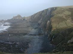
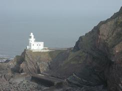
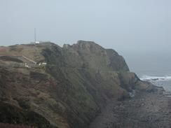
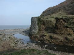
Hartland Point was very nice, and I can well recommend that you visit the viewpoint near the large Ariel. The viewpoint not only gives a good view of the Hartland Point lighthouse but also the wreck of the Johanna, a ship that sunk in 1982. As the tide was out I could see the remains of the ship on the foreshore beneath the cliffs. The stern and bow are both clearly visible although the middle section of the ship is just a large pile of scrap. It was quite an impressive sight, and it is the first time that I have seen a shipwreck fully above the surface of the water. I wish that it had been possible to go down onto the foreshore to have a look around the wreck, but I could see no obvious way for me to get down the cliffs.
Clovelly is a world famous village, but neither Sam nor I were wiling to pay the four pounds needed to go down to view the village. The South West Coast Path follows the attractive Hobby Drive above the village, so I could look down over and into it as I walked along the first part of the drive. I would not have minded going down to have a look around it, but I really could not justify the cost.
Directions
| During this walk I followed the South West Coast Path, the route of which is detailed in the Ordnance Survey National Trail Guide 8, Minehead to Padstow (ISBN 1-85410-774-7). Unfortunately the route description is written in reverse to the direction that I am walking, but the 1:25,000 maps in the book are clear and the signs on the ground are very good. Also to be recommended is the South West Coast Path Association guidebook (ISBN 0-907055-04-4), which has less concise directions and no maps, but includes accommodation details and grades each section of the walk according to difficulty. They also publish reverse directions, which are suitable for walking in the direction that I walked the route. They have a website at www.swcp.org.uk, which is well worth a visit. | 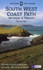
|
| 
| |
| |
| |
Distances
| From | To | Distance (m) | Ascent (ft) | Descent (ft) |
|---|---|---|---|---|
| Hartland Quay | Hartland Point | 3.0 | 1152 | 1014 |
| Hartland Point | Clovelly | 6.7 | 2976 | 2943 |
| lovelly | Buck's Mills | 4.5 | 1421 | 1493 |
This makes a total distance of 14.2 miles, with 5549 feet of ascent and 5450 feet of descent.
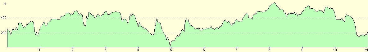
For more information on profiles, ascents and descents, see this page
Accommodation
Mervan would not fit through the gates of the car park in Buck's Mills, and so we had no choice to find another place to park for the night. We drove up the road to the A39(T), and then started to drive eastwards along it. There were a couple of lay-bys beside the road, but I did not fancy spending the night right beside the road. I therefore suggested that we drive into Horns Cross, where I stayed at a B&B on another walk in 2000. I remembered that there was a pub in the village that had a car park, and when we reached the village we found the Coach and Horses Inn was open. we went into the pub and the landlord kindly allowed us to stay in the car park on condition that we bought some drinks, which of course was a real hardship...
Disclaimer
Please note that I take no responsibility for anything that may happen when following these directions. If you intend to follow this route, then please use the relevant maps and check the route out before you go out. As always when walking, use common sense and you should be fine.
If you find any information on any of these routes that is inaccurate, or you wish to add anything, then please email me.
All images on this site are © of the author. Any reproduction, retransmissions, or republication of all or part of any document found on this site is expressly prohibited, unless the author has explicitly granted its prior written consent to so reproduce, retransmit, or republish the material. All other rights reserved.
Although this site includes links providing convenient direct access to other Internet sites, I do not endorse, approve, certify or make warranties or representations as to the accuracy of the information on these sites.
And finally, enjoy your walking!
This walk was mentioned in the following routes:
| My walk around the coastline of Britain |
| South West Coast Path |
Nearby walks
| # | Title | Walk length (miles) |
|---|---|---|
| 85 | Bude to Elmscott | 13.8 |
| 86 | Elmscott to Horns Cross | 15.5 |
| 87 | Horns Cross to Barnstaple | 17.2 |
|
|

|