Walk #313: Hamworthy Station to South Haven Point
 |
 |
|
General Data
| Date Walked | 31/12/2002 |
| County | Dorset |
| Start Location | Hamworthy Station |
| End Location | South Haven Point |
| Start time | 07.45 |
| End time | 14.49 |
| Distance | 18.0 miles |
| Description | This was a long and mostly boring positional walk, getting me around the edge of Poole Harbour to South Haven Point, and the start of the South West Coast Path. |
| Pack | Today I carried my 30-litre Karrimor HotRock rucksack, which was filled with my packed lunch, waterproof leggings, water bottle and a couple of spare shirts, together with the usual assortment of odds and ends. |
| Condition | I felt ill all morning, which was down to a streaming cold and the fact that I was very lethargic. Although this slowly improved throughout the day, I was never operating at 100% and this meant that I found the walk quite hard, Having said that, at the end of the walk I could have walked further if I had so desired. |
| Weather | The weather forecast was for rain, so I was quite glad when the weather was dry for the majority of the day, aside from one drizzle shower. It did start to drizzle once more whilst I was waiting to be picked up, but this was drizzle rather than rain and it did not get me too wet. It was not a very windy day, and it was also quite mild so I was pleasantly warm for most of the day. |
| OS map | Landranger number 195 (Bournemouth & Purbeck, Wimborne Minster & Ringwood) |
 |
 |
|
 |
 |
|
Map of the walk
Maps courtesy of Google Maps. Route for indicative purposes only, and may have been plotted after the walk. Please let me have comments on what you think of this new format. For a detailed table of timings for this walk, please see the table file.
Notes
I decided that I would set off early on this walk, before first light, as I knew that I had a long distance to do before I was due to be picked up. I was not worried about navigation as the first few miles were going to be along roads through the town, so I thought that I would be safe enough. The area looked quite pretty in the dark with all the houses lit up, many with Christmas decorations outside them.
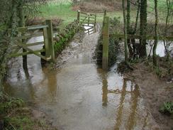
I was gong to do a loop between the Piddle and Frome rivers in Wareham, but when I reached the former river I notice that the river was flooding and I did not fancy walking along a mile or so before finding that the path was flooded. Fort this reason I chickened out of doing that loop, which reduced the distance that I had to walk by a couple of miles, and I walked on into Wareham. In the town I found an Internet Cafe, where I spent a pleasant half-hour checking my emails and looking at a couple of websites. I also noticed that the server that hosts my website is currently down, so I could no longer look at it to check the access logs for the site. This is starting to annoy me, as the service (although free) is doing a very good imitation of a yo-yo at the moment.
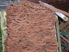
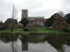
When I was passing through Lytchett Minster I nipped in to have a look at the church, which was unfortunately locked despite lights being on inside. I am getting fed up with churches being locked - I can understand the reasoning behind this, but it is annoying that people cannot visit them just because of a selfish few. For this reason I quite like the work of the Open Churches Society (I believe that is what they are called), which work to keep churches open. A little further on in Wareham I was delighted to come across a wall made out of horseshoes outside a blacksmiths. This wall was a couple of feet thick and about six yards long, and comprised entirely of old horseshoes, with the nails holding them in place. This was absolutely delightful, and I spent a few minutes studying it before having to move on. It is unusual to see horseshoes nowadays, and yet alone so many in one place. Some of them were very small - either from ponies or foals, and others were quite large, and I cannot even begin to estimate how many were in the wall.
I was feeling quite grotty as I walked along the straight A351 road towards Wareham, and I found myself on autopilot as I walked. I nipped into a petrol station on the way so that I could buy myself a can of Red Bull to see if that would remove some of the lethargy, but that did not work. By the time that I reached Wareham I was feeling exceedingly drowsy, and I found it hard to concentrate on the walk. Fortunately this eventually lifted and I started to feel better, but I still had a streaming cold.
I was amused to see some nodding donkeys towards the end of the journey today. These are part of the BP Wytch Farm oilfield, which is the only oilfield on the mainland of the UK. It produced about 4,000 barrels of oil a day, which although a drop in the ocean compared to the UK's usage must nonetheless be useful. I had associated land-based oil rigs with deserts, sand and pollution, so I was surprised to see how well they fitted into the landscape. They are a totally unnatural thing, but they were sited wall beside the forest and did not look massively out of place, even when viewed across a field with cows in them. The forest in the area also helps hide them, but the compounds that the wells were in were fairly clean and tidy, so I must congratulate BP on this.
When I noticed that the server hosting my website was down I got in contact with a friend, Terry, who has been helping me out with these sorts of things whilst I am away and do not have much Internet access. He rung me back later, and he has organised with another friend of mine, Neil, to make the domain point to a mirror of my website on another server whenever the main server is down. The new server has much slower access, but at least the site will always be available. Many thanks to both of them for doing this, as it solves (or at least works around) a problem that has been annoying me for some time.
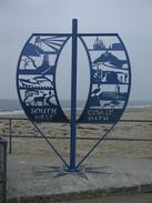
Having reached South Haven Point I am now ready to start the South West Coast Path. I have been waiting for this for a long time, and although it promises to be a very hard walk it should also be quite fantastic in terms of scenery and landscapes. I am very much looking forward to it, and I hope that the challenge does not prove my undoing.
When my brother, his wife Sam and Sam picked me up, we drove the long distance to the campsite. We had a good old chat before getting ready to head out to the bar in the campsite to celebrate the turn of the New Year. Unfortunately I was feeling really i9ll by the time it got to about ten thirty, so I decided to head to bed instead of trying to stray awake for the remaining hour and a half. There was a New Years Eve party in full flow in the bar, and the theme was school uniform so there were many middle-aged people walking about wearing school uniforms, which all added to the sense of fun!
Directions
This walk starts off at Hamworthy Station, which is to immediately to the northwest of Poole. Leave the station and walk down from the station until the B3068 is reached, and then turn left to head for a little over a kilometre through Upton until a junction with the B3067 is reached. Turn left to head westwards though Upton, and follow it as it climbs up to a bridge over the dual carriageway A35 road. Continue along the road as it curves to the left to head southwestwards into the pretty little village of Lytchett Minster.
Pass the church through the village and continue on along the B3067 until it ends at a roundabout with the A351 and A35 roads. At this roundabout head straight on southwestwards down the A351 for about five kilometres, passing three roundabouts as it does so. As the road enters Wareham take a road that leads of to the left as the A351 climbs up to the right. The road leads on and passes under the A351, which passes overhead on a bridge. The road ends at a roundabout right beside Wareham Station.
At the roundabout turn to the left and follow a road that crosses over a level crossing and heads southwards before ending at another roundabout. Continue straight on over the roundabout and follow the B3075 southwards through the town, crossing the River Piddle before climbing uphill. The road descends on the southern side of the town to cross the River Frome on a bridge, and on the other side turn left along a footpath that follows the southern bank of the river southeastwards for a little under a kilometre. When the river turns to the right below the village of Ridge continues straight on uphill along a track that ends at a road in the village.
At the road turn to the left to head eastward for a short distance before turning to the right down another road that heads southwards to a T-junction with another road. Turn left along this road and follow it eastwards for a couple of kilometres away from the village. Near grid reference 957 866 turn right down another road that passes the eastern edge of some woodland on Slepe Heath and descend down to a low-lying area. The road climbs up the other side of the little valley, and at 961 848 take a bridleway that lead off to the left. This bridleway skirts the southern edge of an area of woodland before crossing the Corfe River at Sharford Bridge. On the other side of the bridge turn to the left to follow a footpath that heads northwards and then veers eastwards to end at a track near an oil well.
Head eastwards along this track as it crosses a crossroads and reaches Wytch Farm. At the farm turn to the right to head southwards across a field until a surfaced track is reached. Turn left to head eastwards along this track as it passes an oil well before skirting the northern edge of some woodland. It passes another oil well before meeting another one, where the track turns to the right to head southeastwards. At a crossroads turn to the left and follow a footpath past Ower Farm and down to Newton. The path then joins a track and climbs uphill through an area of woodland before taking a rough easterly course past Greenlands Farm before ending at a public road. At this road turn left and follow it north for a couple of kilometres to the car park beside the ferry landing at South Haven Point, where this walk ends.
Distances
| From | To | Distance (m) | Ascent (ft) | Descent (ft) |
|---|---|---|---|---|
| Hamworthy Station | Wareham Station | 6.7 | 184 | 200 |
| Wareham Station | South Haven Point | 11.3 | 400 | 417 |
This makes a total distance of 18.0 miles, with 584 feet of ascent and 617 feet of descent.
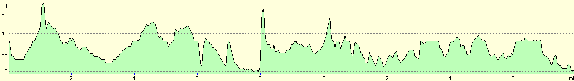
For more information on profiles, ascents and descents, see this page
Accommodation
We stayed at the Warmwell Country Touring Park, Mundays Caravan Park Limited, Warmwell, Dorchester, Dorset, DT2 8JD/ They can be contacted via email at warmwell@btopenworld.com. This site was quite a distance away from where we finished the walk, but it was the only one in the area that could take us in over the New Year. We wanted a site as we had visitors; so staying at the side of a road was not really applicable. The site cost us eleven pounds for the night, and was reasonably well appointed with a nice bar. The showers were not the warmest however, which annoyed me slightly.
Disclaimer
Please note that I take no responsibility for anything that may happen when following these directions. If you intend to follow this route, then please use the relevant maps and check the route out before you go out. As always when walking, use common sense and you should be fine.
If you find any information on any of these routes that is inaccurate, or you wish to add anything, then please email me.
All images on this site are © of the author. Any reproduction, retransmissions, or republication of all or part of any document found on this site is expressly prohibited, unless the author has explicitly granted its prior written consent to so reproduce, retransmit, or republish the material. All other rights reserved.
Although this site includes links providing convenient direct access to other Internet sites, I do not endorse, approve, certify or make warranties or representations as to the accuracy of the information on these sites.
And finally, enjoy your walking!
This walk was mentioned in the following routes:
| My walk around the coastline of Britain |
Nearby walks
| # | Title | Walk length (miles) |
|---|---|---|
| 312 | Southbourne to Hamworthy Station | 15.3 |
| 314 | South Haven Point to Worth Matravers | 16.7 |
| 315 | Worth Matravers to Lulworth Cove | 12.7 |
|
|

|