Walk #298: Beachy Head to Peacehaven
 |
 |
|
General Data
| Date Walked | 16/12/2002 |
| County | East Sussex |
| Start Location | Beachy Head |
| End Location | Peacehaven |
| Start time | 08.05 |
| End time | 14.47 |
| Distance | 16.7 miles |
| Description | This was a beautiful walk, taking in Beachy Head and the Seven Sisters. |
| Pack | Today I carried my 30-litre Karrimor HotRock rucksack, which was filled with my packed lunch, waterproof leggings, water bottle and a couple of spare shirts, together with the usual assortment of odds and ends. |
| Condition | I feel absolutely fine after this walk, and have no problems of any kind to report aside a general and expected fatigue. My legs did not suffer from all of the ascents and descents, and at the end of the walk I could easily have waked further if the need had arisen. |
| Weather | Today's weather was far better than yesterday's, which I am thankful for. There was no sign of any rain at all during the day, although there was thick cloud in the sky overhead that only occasionally had breaks in it. The wind was light and came from behind me, which was helpful, and it was not a cold day. |
| OS map | Landranger number 199 (Eastbourne & Hastings, Battle & Heathfield) and Landranger number 198 (Brighton & Lewes, Haywards Heath) |
 |
 |
|
 |
 |
|
Map of the walk
Maps courtesy of Google Maps. Route for indicative purposes only, and may have been plotted after the walk. Please let me have comments on what you think of this new format. For a detailed table of timings for this walk, please see the table file.
 |
 |
|
 |
 |
|
Notes
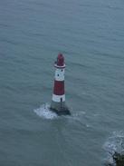
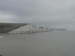
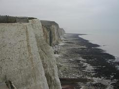
I am very glad that I cut yesterday's walk sort and saved the walk over the Seven Sisters for today. The weather was far better than it had been yesterday, and that allowed me to get far better views over the hills (although not as good as if the weather had been clear). I spent some time dawdling about the Beachy Head area, getting close to the cliffs edge so that I could take photographs. This lead to a strange situation where I could almost mentally balance my desire for getting a good photograph with the perceived risk of falling over the edge. The views were fantastic, even in the cloud, and it was well worth walking slowly and taking it all in.
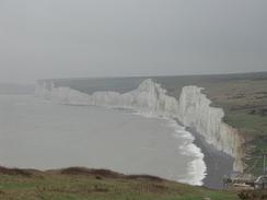
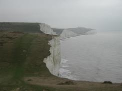
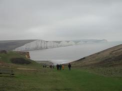
I had been looking forward to the climb up over the Seven Sisters in a strange way - it was going to be a highlight of the day, yet it was going to be the first really strenuous bit of walking I have done for many weeks, so I was also slightly apprehensive about it. In the end I found it fairly easy, and the views more than compensated for the energy spent on the climbs. In many ways I found some of the steep descents to be harder than the ascents, as the grass was quite wet and I had to be careful not to slip.
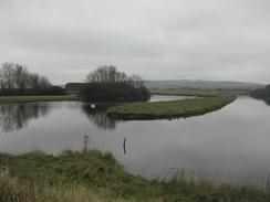
I had arranged to meet up with Sam at the Seven Sisters Country Park at Exceat for lunch. There was some leftover pasta from dinner last night, so she heated that up for me whilst I devoured a cheese roll. Meeting Sam for lunch is very nice when it happens, although it does delay me more than I like, but if I need to have a break it is lovely to have a break with Sam. The diversion inland from Cuckmere Haven to the country park may not be strictly necessary - according to a local it is possible to easily wade across the channel at low tide, although the tide was not low enough to do so when I passed it. The country park itself is very nice, and apparently the valley of the river is the last unspoilt and undeveloped river estuary on the south coast.
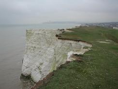
I found the 282-foot climb up to Seaford Head from Cuckmere Haven to be absolutely lovely, and I stopped occasionally to get some quick views back over the Seven Sisters. Near the bottom of the climb I passed a group of Ramblers who were making their way slowly up the hill, and I flew past them, exchanging a few pleasantries with some of them as I passed them. This has made me realise that although I am not as fit as I want to be, I am still quite fit. I have lost a lot of weight since the start of the trip, as my trousers can testify (they used to hug my frame, and there is now a pronounced gap of an inch or so between belly and trousers). This amazes me, as I had not thought of myself as being particularly overweight before the trip. Perhaps I could set up a slimming club where all the participants have to walk 1,300 miles?
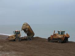
I found Newhaven to be quite interesting. Ferries run from the town into Dieppe, and it had all the air of being a port town. Although the town was fairly grey I still found much of interest in it - from a Seacat ferry at the quay to the swing bridge over the river and the fort above the town. The latter was particularly interesting, and it is now a museum. Although it was closed when I passed. On the cliffs near the fort there were lots of signs of military occupation - concrete bases for guns, pillboxes of various sizes and a couple of old observation posts. The whole area was quite fascinating, and I was tempted to go exploring through the undergrowth to see what I could find.
The walk ended at the King George V Memorial in Peacehaven. This memorial is situated on the Greenwich Meridian, and this is the last time on the walk that I will pass over the meridian, having passed it five times before. The memorial itself is very nice, with a green globe on the top of it and a list of names and distances to various places in the Commonwealth. I spent some time studying it, comparing the distance I am walking with the list of names and numbers, and although none matched exactly I am walking early the equivalent of walking to Singapore!
As of today I have walked over 2,000 miles so far this year, and although the majority of that total has been on one triup I am still ecstatically happy about reaching that total. Next year if all goes well on this trip I should walk about 4,000 miles - an amazing figure to even contemplate walking in a year, and nearly as much distance as I have done in the last four years combined! To celebrate reaching this figure Sam bought a bottle of wine, and we drank this with dinner. This had the unfortunate side effect of making me very sleepy, and I had a nap for an hour before getting up at eight and finally going to bed at nine.
Directions
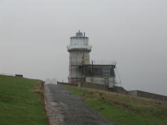
This walk starts off at the pub at Beachy Head. Up to the Seven Sisters Country Park it follows the South Downs Way, which is well waymarked. Leave the pub car park and head towards the edge of the cliff. Near the edge a path leads off to the right, initially heading southwestwards before turning to head westwards. The cliff edge rises and falls before eventually descending down to the road at Birling Gap.
Follow the road around the bend past the hotel and then turn left along a track that heads uphill. When the track ends continue straight on along a footpath that leads up to the top of the first of the Seven Sisters. Walk along the path as it rises and falls over the hills, passing two monuments on the way before eventually reaching Cliff End, which is poised above Cuckmere Haven.
At Cliff Ends turn right and follow the South Downs Way as it slowly descends northwards from the hills. When it meets a track on the valley floor turn right and follow this track as it heads northwards to the Seven Sisters visitor centre at Exceat, which is beside the A259 road. Turn left down the road and follow the pavement to Exceat Bridge. This is a narrow one-lane bridge, so you have to be careful crossing it as there is no pavement.
On the other side of the bridge turn left into the car park of a pub. Go through the car park, and on the southern edge of it a footpath leads off southwards. Follow this footpath beside the river for a couple of kilometres until it reaches some houses above Cuckmere Haven. Here the path turns to the right and head uphill beside the edge of the cliff. When it eventually reaches the top of Seaford Head it then drops steeply down past a golf course until it reaches the shingle beach at Seaford.
Turn right and walk northwestwards for a couple of miles along the seafront through Seaford, passing the last Martello Tower on the coast until just before the docks are reached. Here turn right to head northwards along a path through some derelict land, passing between the beach and a large lake called Mill Creek.
Turn right, and follow a path northwards that leads to a bridge over the lake. Head over this bridge, and on the other side turn left to reach a footbridge over the railway line. Cross the railway line and on the other side turn left down a road that immediately passes Newhaven Harbour Station before curving to the right to head northwards through the town.
The road ends near Newhaven Town Station. Turn left along a road that leads up to another road, the A259 once again. Cross the River Ouse using this bridge and on the other side turn left down a footpath and cycle path that leads southwards along West Quay. When the path ends continue on through the docks and out to another road. Here turn half-left and head uphill along a steep surfaced path that leads up to the front of Newhaven Fort. Turn right and walk along the side of the fort past the car park and then turn left once more to meet the cliff edge.
Turn right to walk westwards along the cliff edge. There is a path that leads alongside the cliffs past the coastguard station, but it is indistinct so care needs to be taken. The path continues on over Peacehaven Heights before descending slightly down into the town of Peacehaven itself. Here a rough track runs alongside the path and the cliff edge, and a little way along this the King George V Memorial is reached, where this walk ends.
Distances
| From | To | Distance (m) | Ascent (ft) | Descent (ft) |
|---|---|---|---|---|
| Beachy Head | Exceat Bridge | 6.6 | 1985 | 2490 |
| Exceat Bridge | Newhaven swing bridge | 6.3 | 1158 | 1161 |
| Newhaven swing bridge | Peacehaven | 3.8 | 764 | 659 |
This makes a total distance of 16.7 miles, with 3907 feet of ascent and 4310 feet of descent.
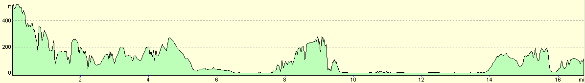
For more information on profiles, ascents and descents, see this page
Accommodation
We stayed at the excellent Sheepcote Valley Caravan Club Site, East Brighton park, Brighton, BN2 5TS. This was a lovely site, with clean toilets and piping hot showers. They can be contacted by telephone on 01273 626546.
Disclaimer
Please note that I take no responsibility for anything that may happen when following these directions. If you intend to follow this route, then please use the relevant maps and check the route out before you go out. As always when walking, use common sense and you should be fine.
If you find any information on any of these routes that is inaccurate, or you wish to add anything, then please email me.
All images on this site are © of the author. Any reproduction, retransmissions, or republication of all or part of any document found on this site is expressly prohibited, unless the author has explicitly granted its prior written consent to so reproduce, retransmit, or republish the material. All other rights reserved.
Although this site includes links providing convenient direct access to other Internet sites, I do not endorse, approve, certify or make warranties or representations as to the accuracy of the information on these sites.
And finally, enjoy your walking!
This walk was mentioned in the following routes:
| My walk around the coastline of Britain |
Nearby walks
| # | Title | Walk length (miles) |
|---|---|---|
| 297 | Norman's Bay to Beachy Head via Eastbourne | 10.8 |
| 299 | Peacehaven to Worthing via Brighton | 20.5 |
| 596 | Wivelsfield to Newhaven | 22.7 |
|
|

|