Walk #173: Cwmcynwyn to Pontsticill via Pen y Fan
 |
 |
|
General Data
| Date Walked | 28/12/2001 |
| County | Powys, Mid Glamorgan |
| Start Location | Cwmcynwyn |
| End Location | Pontsticill |
| Start time | 08.20 |
| End time | 13.48 |
| Distance | 11.5 miles |
| Description | This was a highly enjoyable walk taking in Pen y Fan, the highest point in Powys. |
| Pack | Full camping kit, with four-season sleeping bag. |
| Condition | I found the climb up to the top of Pen y Fan to be harder than I was expecting considering that I did not carry my pack up, which shows that I am out of shape. I was slightly fatigue at the end of the walk but with a little rest I could have continued further if daylight had permitted. The underside of my feet were aching slightly, with a couple of hot-spots developing on them. My shoulders also ache slightly as a result of carrying a heavy pack for the first time in months. |
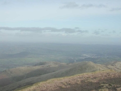
| Weather | The main feature to today's weather was the wind, which was very strong and gusty at times. This was particularly noticeable at the top of Pen y Fan where some of the gusts threatened to blow me over. Fortunately there was a combination of high cloud and sunny patches which meant that despite the wind there were panoramic views available from the top. There was no sign of any rain all day, which was a relief as there would have been significant wind-chill effects if I had got wet. |
| OS map | Outdoor Leisure number 12 (Brecon Beacons - Western & Central Areas) |
 |
 |
|
 |
 |
|
Map of the walk
Maps courtesy of Google Maps. Route for indicative purposes only, and may have been plotted after the walk. Please let me have comments on what you think of this new format. For a detailed table of timings for this walk, please see the table file.
Notes
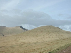
This walk was going to be literally the high point of the entire trip, as I was due to climb Pen-y-Fan, the highest point in the Brecon Beacons and South Wales. Because it had been raining and misty the previous day I awoke before dawn with some trepidation, only to find when daylight came the cloud level was above the tops of the hills.
The track from Cwmcynwyn up to Bwlch ar y Fan (the gap between Cribyn to the west and Fan y Big to the east) was fairly good and rose slowly on a fairly gradual gradient for most of the way, although I could tell that I was not used to carrying the pack because I was running out of breath occasionally.
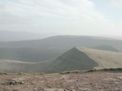
When I go to Bwlch ar y Fan I did not fancy climbing Cribyn, so I took a path that led around the southern flank of the hill and led to the col between Cribyn and Pen y Fan. Here I dropped off my pack as I did not fancy carrying it all the way up the hill only to come back the same way again.
On the start of the climb up to the top of Pen y Fan from the col I met a gentleman descending who was wearing army fatigues and was carrying a large bergen. I chatted to him for a while, and it turned out that he was a Royal Marine from Southampton who was getting familiar with the area before hopefully doing selection in January. Later on as I descended from the top I met him again, making his way up. I wished him the best of luck as he shot up the hill.
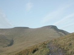
The wind on the top of Pen y Fan was quite strong, and it made the little scramble up the last part of the climb quite difficult. Fortunately there was bright sunshine at the top, and I got some very expansive views. At the top I could find the cairn but not the trig point; I was told later that it was removed five years earlier during an archaeological dig.
After I had made my way down from Pen y Fan back to the col and picked up my rucksack I met two gentlemen who were wardens for the national park. I talked with them all the way back to the track at Bwlch ar y Fan, and it was quite interesting hearing some of their stories. One of them is mentioned in next Saturday's Times travel supplement, so when I get down to Merthyr Tydfil I shall purchase a copy and have a look.
From Bwlch ar y Fan a good track led down to the east of the Upper Neuadd Reservoir and down into the Taf Fechan Forest. After this it joined a tarmacced road and passed to the west of the Pentwyn Reservoir and then the Pontsticill Reservoir, before eventually coming to Pontsticill village. By the time I reached the village I was fairly tired, and with four miles to go to get to Merthyr Tydfil (or six miles using my preferred route avoiding roads) I decided to spend the night in the village and do the rest of the journey into town the next day.
Directions
This walk starts off at Cwmcynwyn farm, in the foothills of the Brecon Beacons, four miles south of Brecon. Just past the farm buildings turn left and take a very rough track that leads uphill to the west for a couple of hundred metres until it ends at a gate. Go through the gate and turn left to join a track that heads in a roughly southerly direction.
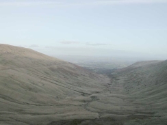
Shortly after this track is joined another track leads off to the right which heads up the ridge of Bryn Teg to the summit of Cribyn. Do not take this path but continue along the main track that skirts the hillside halfway between Bryn Teg above and Cym Cynwyn below. As it heads southwards it slowly ascends as the nick in the head of the valley becomes more visible. After a couple of kilometres the path starts to steepen and veer to the southeast as it climbs up to Bwlch ar y Fan, the low point between Fan y Big to the left and Cribyn to the right.
At Bwlch ar y Fan a stile to the right allows access over a fence. From the stile an obvious path leads off to the west up to the summit of Cribyn. Another track leads off slightly further to the south, and this track contours around the side of Cribyn rather than climbing to the summit. This is the path I took, and it allows some lovely views over the Upper Neuadd Reservoir to the south and Pen y Fan and Corn Du to the west.
The path eventually reaches a little col between Cribyn to the east and Pen y Fan to the west. When the path meets a path leading between the two hills turn left and start the climb westwards along the Craig Cwm Sere to the top of Pen y Fan. The last part of the climb is very steep up to the small plateau at the summit of the hill.
Descend by the same route along Crag Cwm Sere to the col, and then follow the path back around the southern flank of Cribyn to Bwlach ar y Fan. Cross the stile over the fence and back onto the track.
Turn right and start the long descent southwards along the track as it passes to the east of the Upper Neuadd Reservoir. Just past the reservoir the track descends steeply down to the Nant y Gloesydd stream and then steeply back up to the other side to enter the Taf Fechan Forest. About half a kilometre further on the track meets a minor tarmacced road.
Join the road and continue southeastwards along the road as it heads through the forest. At Pont Cwmyfedwen it passes a car park and crosses the Taf Fechan river at a lovely spot, with the water swirling beneath the bridge.
Just under a kilometre from the bridge the road ends at a T-junction with a larger road. Join this road and follow it as it heads south-southeastwards for about one and a half kilometres along the western edge of Pentwyn Reservoir to another road junction at the northern end of Pontsticill Reservoir.
Continue along the road as it skirts the western edge of Pontsticill Reservoir. Near the road junction the Taff Trail heads off to the right along a track; this meets up with the road at the southern end of the reservoir and could be used to provide a more picturesque route than the one that I took along the road. Just under a kilometre south from the road junction the road crosses the Nant Car Fach stream at Cwm-Câr where it runs into Pontsticill Reservoir. From Cwm-Câar the road continues on for a little over a mile past a road junction as it descends into the little village of Pontsticill. The Red Cow Inn is on the right as you enter the village.
Distances
| From | To | Distance (m) | Ascent (ft) | Descent (ft) |
|---|---|---|---|---|
| Cwmcynwyn | Bwlch ar y Fan | 2.2 | 948 | 39 |
| Bwlch ar y Fan | Pen y Fan summit | 1.5 | 961 | 52 |
| Pen y Fan summit | Bwlch ar y Fan | 1.5 | 52 | 961 |
| Bwlch ar y Fan | Pontsticill | 6.3 | 384 | 1243 |
This makes a total distance of 11.5 miles, with 2345 feet of ascent and 2295 feet of descent.
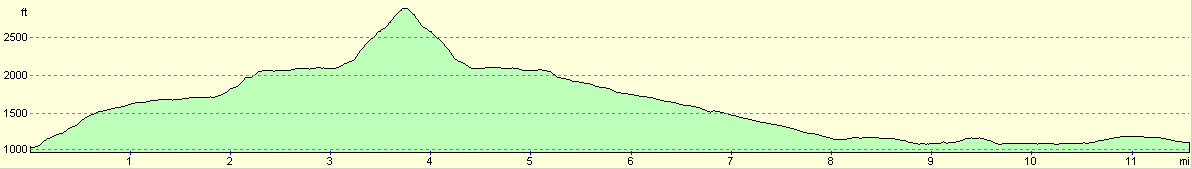
For more information on profiles, ascents and descents, see this page
Accommodation
I stayed at Pen Rhadwr, a B&B at the top of the hill at the southern end of Pontsticill. This was a very nice B&B that cost thirty pounds for the night for a single en-suite room. Phone (01685) 723627 and ask for accommodation at Pen Rhadwr, as the same number also deals with accommodation in Merthyr Tydfil and elsewhere. Alternatively look at their website for more information. The landlord at the Red Cow Inn told me that they were going to start doing B&B service in the Summer, so it may be worth trying there as well.
Disclaimer
Please note that I take no responsibility for anything that may happen when following these directions. If you intend to follow this route, then please use the relevant maps and check the route out before you go out. As always when walking, use common sense and you should be fine.
If you find any information on any of these routes that is inaccurate, or you wish to add anything, then please email me.
All images on this site are © of the author. Any reproduction, retransmissions, or republication of all or part of any document found on this site is expressly prohibited, unless the author has explicitly granted its prior written consent to so reproduce, retransmit, or republish the material. All other rights reserved.
Although this site includes links providing convenient direct access to other Internet sites, I do not endorse, approve, certify or make warranties or representations as to the accuracy of the information on these sites.
And finally, enjoy your walking!
Nearby walks
| # | Title | Walk length (miles) |
|---|---|---|
| 172 | Brecon to Cwmcynwyn | 4.2 |
| 174 | Pontsticill to Merthyr Tydfil | 6.0 |
|
|

|