Walk #620: Cotswold Way: Dowdeswell Reservoir to Stanton
 |
 |
|
General Data
| Date Walked | 28/07/2004 |
| County | Gloucestershire |
| Start Location | Dowdeswell Reservoir |
| End Location | Stanton |
| Start time | 08.50 |
| End time | 17.54 |
| Distance | 19.8 miles |
| Description | This was yet another highly enjoyable stroll, with some superb scenic views only slightly spoilt by the ascents needed to get to them. |
| Pack | Today I carried my 75-litre Craghoppers Rucksack. I did not carry my camping gear, but I did have more other assorted gear with me, which made up for most of the weight of the camping gear. |
| Condition | I feel fitter after this walk than I have for any of the others on this trip so far, despite it having been a fairly strenuous day's walk. The undersides of my feet are not aching too much, and my legs are fine. I have developed some redness on my shoulders, but that is only to be expected. |
| Weather | This was yet another dry day with a mixture of sunshine and clouds, with no sign of any rain. It got slightly hot at times, but at others a cooling breeze worked wonders and helped me keep comfortable. |
| OS map | Landranger number 163 (Cheltenham & Cirencester, Stow-on-the-Wold) and Landranger number 150 (Worcester & The Malverns, Evesham & Tewkesbury) |
 |
 |
|
 |
 |
|
Map of the walk
Maps courtesy of Google Maps. Route for indicative purposes only, and may have been plotted after the walk. Please let me have comments on what you think of this new format. For a detailed table of timings for this walk, please see the table file.
 |
 |
|
 |
Notes
My sleep last night was quite unusual for me - at about nine thirty I was reading, and an hour later I woke up with the book still in my hand. I closed my book again, and when I woke at five I read once more before yet again falling asleep for another hour. It is highly unusual for me to got back to sleep once I am awake, and must be a sign of exactly how strenuous I found yesterdays walk. Once I woke up properly and done my morning ablutions I had a lovely breakfast, and chatted to another guest who was an ecologist from Cambridge who was studying the grass uplands. It felt strange to meet someone else from Cambridge, a link with a place that I would soon be back in; a link to reality. When I am on a trip like this it becomes very hard to believe that I have a life outside of walking and work generally goes right out of my mind; the walk is all that matters, and perhaps that is the way that it should be,
After chatting to the landlord and landlady for half an hour I eventually set off from the B&B. The first section was steep and I soon found myself puffing and panting until the path emerged from some woodland and the gradient slackened. The Way crossed Ham Lane and then headed on across fields. It was not the best stretch of the Cotswold Way, and I out my mind into neutral as I followed the path northwards. It soon joined a road, and I followed this northward until it diverted off to the left downhill at a crossroads. This new road was soon left behind, and the walk became much nicer as it headed northwards, aiming for the western edge of Cleeve Common. I soon reached an old abandoned quarry, which was complete with an old, abandoned burnt-out car, and here the usually good way marking of the Cotswold Way let me down and it took me a couple of minutes to work the correct way out.
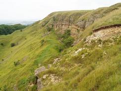
The path followed the Happy Valley, a slump trough feature northwards, rising and falling by small amounts as it headed for Cleeve Cloud. As I neared the top of Cleeve Hill the path crossed a golf course, with the path across the fairways being very well marked. With the trig pillar in sight I said hello to a couple who were out walking, and I was amazed to find that the gentleman was in his early seventies - he looked at least twenty years younger. We chatted for a while, and it turned out that they led guided walks, and they were doing a walk prior to guiding it in the next few days. They were a wonderful couple, and I enjoyed my chat with them, but with the pillar so close I said goodbye and wished them well, before climbing up to the pillar and the adjacent topograph. The views were great, and it was worth pausing for another couple of minutes to let the views sink in. It is obviously a well-visited location, as it should be with such expansive views.
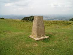
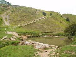
Once I left the pillar and topograph the Way headed downhill and skirted north around the side of Cleeve Hill across yet more fairways, before joining a track. The Cotswold Way diverted from the track near the golf clubhouse, and continued level before descending steeply into a dry valley. The descent was bad enough, but the ascent that came immediately afterwards looked stunningly steep. The path crossed a stream at The Washpool, and I started the steep ascent to get up to the top of Cleeve Common once again. Strangely enough I did not find the ascent hard at all, and I got to the top in seemingly no time without stopping. Once at the top I knew that my next target, the trig pillar at the southern edge of Cleeve Common, was nearby (although slightly off the Cotswold Way), near to the large masts that dominate the common. The pillar, at 330 metres, is the highest point in Gloucestershire, and I could therefore tick it off my list of county tops that I am visiting. It seemed like a good opportunity to sit down and have a rest, so I took my rucksack off and climbed up to sit down on top of the pillar.
After ten minutes I could see a couple of people slowly making their way towards me from the direction of the masts and, not wanting to lose the solitude, I got down, out on my rucksack and headed back to the Cotswold Way. The Way started to head downhill, and eventually joined a track that passed Wontley Farm. The route was easy to follow on the map from the farm, but there were some confusing way markers on gateposts that seemed to indicate that the Way headed southwards down another track. I stood and looked at the map for a few minutes before eventually choosing what proved to be the correct track, which headed uphill slightly to the northeast from the farm. After following the track for about half a mile, the Way left it and turned to head eastwards across fields, heading for the spectacular Belas Knap long barrow.
Belas Knap long barrow is a fantastic example of a long barrow, and, although it has been slightly restored, is well worth visiting, even if you are not walking the Cotswold Way. There are four burial chambers, the entrances to which are quite small, and a fantastic large false entrance that dominates the mound. I could not help but walk slowly around the mound, looking in all of the chambers, and just soaking up the atmosphere that permeates the area surrounding the mound. There was a nearby information board that gave me more information, including the fact that when the barrow was opened the chambers contained the remains of 38 human skeletons, along with other artefacts from the end of the Neolithic or New Stone Age, circa 2000 BC. In the company of a Dutch couple I left the site, and started the slow descent northeastwards towards Wadfield Farm, which included a short stretch of road walking. The path then took a more northerly course, heading across fields as the descent slackened before joining a road near to the entrance to Sudeley Castle, and reached the centre of Winchcombe.
I must admit that I was quite taken by Winchcombe, which proved to be quite an attractive town. By this time I was in need of another rest, and so I decided that it may be best to stop off in a pub for a drink. Down a side street in the town I found the Sun Inn, and I decided that this would be a good place to stop. The pub was almost deathly quiet with only two other customers who were playing pool in a different room, so I got my walkman out and listened to the Archers on Radio 4 as I slowly supped my pint. I had taken my boots off so that I could give my overheated feet some air, and I soon decided that they needed a little more time to cool down, and so another pint soon followed. Eventually I decided to leave the pub and, realising that I still had a fair few miles to walk, I set off out of the town. If anything the houses on the northern side of the town were even more picturesque than those in the centre, and it was with some regret that I crossed the river and headed northeastwards along Puck Pit Lane.
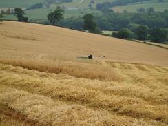
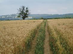
When the lane ended navigation across the fields proved to be slightly bothersome as the crops had been cut and the path was not very obvious on the ground. By sticking to a northeasterly direction I did not go too wrong, and in a short time I found myself staring at the ruins of Hailes Abbey. This late Cistercian abbey, built during the mid-13th century, is now run by English Heritage and this meant the usual entrance fee to visit the site. I really could not afford the time that would make paying a fee worthwhile, so I simply looked through gaps in a fence towards some of the ruins, which were not the most dramatic abbey ruins that I have ever seen. All I could make was a wall with several arches within it, and there did not seem to be much else in the area, although there may well have been more of interest that was out of my sight. Next to the abbey is a small church, which actually predates the abbey by 100 years, and is meant to be exceedingly nice inside. The car park beside the church was full and I really could not be bothered to have a look inside; yet again on this trip apathy won.
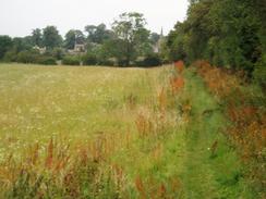
From the abbey a track headed uphill to the southeast, passing the Abbey car park and then following the southern edge of Hailes Wood. Shortly after the wood ended the Cotswold Way left the track and headed in a rough northeasterly direction towards the old hill fort at Beckbury. This was not the most impressive that I had seen on the walk, and I did not pause to have a look around it and instead followed the Way to a track that headed northeastwards past the farm at Upper Coscombe to reach the B4077 road at Stumps Cross. The road was busy and fortunately the path did not follow it, but diverted along a footpath that headed northwestwards, skirting the farm at Lower Coscombe before reaching the end of a track in Wood Stanway. This is an extremely small village, and almost as soon as the road proper was reached, The Way turned off it to follow another footpath northwards. This headed towards the scarcely larger but more attractive village of Stanway. This is dominated by two main buildings; the church, and the gateway entrance to Stanway House, both of which are very imposing structures. The houses in the village are quite pretty as well, and it would have been a nice place to spend the night had I not booked myself in at a B&B at Stanton, a mile further north. To get there the Cotswold Way crosses some attractive parkland before crossing a couple of fields. My initial glimpses of Stanway did not show much promise as the side of the village that I entered had bungalows on it, but I soon found myself in a village with some magnificent stone buildings.
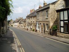
I arrived at my B&B to see a group of people waiting outside. I asked them if this was The Vine, and they responded that it was, but that the proprietors were out. This surprised me slightly as I was hardly early, and so I shrugged my pack off and went to sit down on some chairs outside the pretty property. During this time various American tourists came in and out, and I got out a book and started reading. After half an hour I felt that this was getting slightly ridiculous, and so I tried ringing the phone number that I had rung last night to book the room. I could hear the phone ringing, which meant that I had the correct place, but where were the owners? My question was answered ten minutes later, when a man arrived and showed me into my room. I was quite annoyed, but one look at the room improved my mood, as a four-poster bed dominated it. I had a shower, made a couple of phone calls, and then headed uphill to the aptly-named 'The Mount' pub, which gave some superb views over the hills and the village itself. The walk up to the pub had been steep but beautiful, with a wide street and many superb examples of Cotswold stone cottages lining the street; it was the nearest thing to an unspoilt village that I have seen so far on the trip. As I sat in the pub eating my meal and supping a pint, it occurred to me that life rarely got better than this. I was not too exhausted despite the long and hilly walk, I was feeling relatively fine, and I was sitting in a pub looking at some glorious views - what more could a man want?
Directions
|
This walk follows the Cotswold Way, which is a well waymarked path that is soon to become a National Trail. I used a guidebook for the walk called 'The Cotswold Way', by Mark Richards (see below). This guidebook is written for north to south walkers and therefore the directions are not quite as useful for the south to north walk, but the hand-drawn strip maps are exceptionally good, and can be read easily from either direction. There was a recreational path guide published for the route, but this is out of print and will only be re-issued, as a National Trail Guide once the path has officially become a National Trail. If you wish to buy the guidebook for the Cotswold Way that I used, then please click on the link to the right: |  |
Distances
| From | To | Distance (m) | Ascent (ft) | Descent (ft) |
|---|---|---|---|---|
| Dowdeswell Reservoir | Cleeve Hill | 4.8 | 1119 | 456 |
| Cleeve Hill | Winchcombe | 7.5 | 840 | 1572 |
| Winchcombe | Stanton | 7.5 | 965 | 915 |
This makes a total distance of 19.8 miles, with 2924 feet of ascent and 2943 feet of descent.
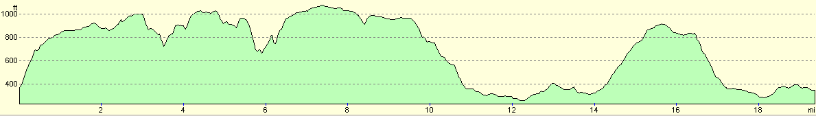
For more information on profiles, ascents and descents, see this page
Accommodation
I spent the night at the Vine B&B, Stanton, Gloucestershire WR12 7NE. Mrs Carenza can be contacted on (01386) 584250. The room cost me thirty-five pounds for the night.
Unfortunately my room at the B&B (Room 5) was based right below the hot-water boiler, and so whenever someone has a bath or shower I had to put up with a long and loud interruption that I was not best pleased about. This, and the way that no one was around to book me in when I arrived, leaved me less than pleased.
Disclaimer
Please note that I take no responsibility for anything that may happen when following these directions. If you intend to follow this route, then please use the relevant maps and check the route out before you go out. As always when walking, use common sense and you should be fine.
If you find any information on any of these routes that is inaccurate, or you wish to add anything, then please email me.
All images on this site are © of the author. Any reproduction, retransmissions, or republication of all or part of any document found on this site is expressly prohibited, unless the author has explicitly granted its prior written consent to so reproduce, retransmit, or republish the material. All other rights reserved.
Although this site includes links providing convenient direct access to other Internet sites, I do not endorse, approve, certify or make warranties or representations as to the accuracy of the information on these sites.
And finally, enjoy your walking!
Nearby walks
| # | Title | Walk length (miles) |
|---|---|---|
| 619 | Cotswold Way: Painswick to Dowdeswell Reservoir | 18.2 |
| 621 | Cotswold Way: Stanton to Lower Quinton | 17.0 |
| 1018 | A circular stroll between Shipston-on-Stour and Chipping Campden | 23.0 |
|
|

|