Walk #475: Kildonan to Sannox
 |
 |
|
General Data
| Date Walked | 17/06/2003 |
| County | Strathclyde |
| Start Location | Kildonan |
| End Location | Sannox |
| Start time | 07.55 |
| End time | 17.54 |
| Distance | 18.9 miles |
| Description | This was a lovely long plod along roads up the eastern coat of Arran, through the villages that throng this beautiful stretch of coastline. |
| Pack | Today I carried my 70-litre Craghoppers rucksack with full camping gear, including four days food. |
| Condition | I feel quite good after this walk, aside from a general aching on the underside of my left foot at the end of the walk, a recurrence of the problem that I thought had gone. |
| Weather | Today was quite a mixed day weather wise; early on it was quite cloudy and there was twenty minutes of rain of varying intensities, but this afternoon was sunny and quite warm, with not much wind to cool me down. |
| OS map | Landranger number 69 (Isle of Arran) |
 |
 |
|
 |
 |
|
Map of the walk
Maps courtesy of Google Maps. Route for indicative purposes only, and may have been plotted after the walk. Please let me have comments on what you think of this new format. For a detailed table of timings for this walk, please see the table file.
 |
 |
|
Notes
Today has been an absolutely superb day. It had been a day of meeting people, chatting to people and enjoying the sheer giddy height of being in Scotland. Life does not get much better that today, and for that I am thankful. When I first got the idea to walk around Arran a month ago the main aim was to go up Goat Fell (the highest mountain on the island). When I came onto the island the weather forecast was for better weather today than yesterday, and so I chose to walk around the island anticlockwise so that I would get to the base of the mountain in good weather. Unfortunately the forecast was wrong, and whilst yesterday was superb this morning was overcast and wet. This afternoon the weather lifted leaving a beautiful sunny sky, but this was too late as many of the people I met were coming down from the summit of the mountain. But I am not concerned at not having climbed the mountain - it gives me an excuse to come back to this beautiful place in the future.
When I hoisted my pack onto my shoulders this morning I noted with pleasure that they did not ache - a vast difference to yesterday morning. As I headed up the hill from the campsite an old, classic campervan stopped and they gave me a donation of a fiver - an example of the kindness that was endemic today. At the top of the hill there was twenty minutes of rain from a big black cloud overhead, and as it was warm and there was blue sky around I did not bother to put my coat on and enjoyed getting wet. I had a little ten-minute rest in Lamlash before going on. Sam was catching the ferry and bus over, and we had arranged to meet at midday at the ferry terminal in Brodick. By rather amazing coincidence I arrived at two minutes past midday - not bad timing after an eleven-mile walk! As I plodded heavily down the steep hill to the terminal, trying not to let my heavy pack cause me to run, I saw Sam waiting for me, and my heart gave a leap of joy. We had only been apart for less than two days, but it had felt like a lifetime apart.
We had a little meal in the Stalker's cafe in the town, and had a chat about this and that. Sam wanted to go on a bus ride around the island, so after the meal I said goodbye and felt my heart give a twang at the parting. I knew that I only had about six miles to go to reach the place that I intended to camp, and that the day was early, but I felt that the afternoon was so nice I would just dawdle along. After a couple of miles by the old quay near Brodick Castle I met three Glaswegians, who I chatted to for well over an hour. They had been staying there for four days, slightly hidden from the road and with a lovely view south over Brodick Bay to Brodick. They made me a greasy cup of tea and we chatted the time away, thinking as we did so that this transient lifestyle could become addictive if I was not careful.
I looked at their tents, and commented on the fact that my tent was much larger than the ones that they have slept in. When I brought my tent, which has served me very well over the last few years - I wanted to get a two-man tent. This means that it is much larger and heavier than I need for most of the time, as I have only ever slept with someone else in it once. But I like the feeling of space that I have in it, the fact that I can have all my kit inside the tent with me and not have to keep it all in the porch. And I like the colour - the bright yellow lets everyone knows where I am. A smaller tent may save me a couple of pound in weight, but I would lose the palatial feeling of home that this tent gives me. Inside the tent I have to have order - I sleep on the right as you look in, and my kit goes on the left. The empty tent bags, sleeping bag and roll mat cover go in the pockets on the left hand side of the tent, and meths, torch and mobile go in the right-hand pocket, thus being available if I need them in the middle of the night. If I wake up in the middle of the night and need to use the torch to go out for a pee, I automatically reach into that pocket to find the small shape of the torch. Failure to find it here causes panic and the throwing of everything inside the tent to find it. Order is not everything in life, but in small ways life can be more bearable if there is order.
I soon set off again, and within a few minutes I was greeted with the lovely sight of two seals, one grey and the other mottled black, lying on a rock near the shore. I stopped and watched them for a few minutes, captivated by the scene. On the east coast I had seen many dead seals, killed by the distemper that was seeping the area, but the sight of live seals so close to me was absolutely magical. As I progressed I met a group of three ladies who joined the road in front of me. I started chatting to them, and asked them about the conditions on Goat Fell, which they had just been up. When they reached the hotel in Corrie they asked me if I wanted a drink, and as I had plenty of time I agreed. There followed a very pleasant forty minutes, chatting about the trip and life in general. It was yet another moment today that felt magical, and I left wishing that I could bottle my euphoria of that moment up and save it for times when I really needed it.
A few people had told me that there was a place that people could camp near the hotel in Sannox, and so I entered the hotel and enquired about it. They pointed me to the place that was in a beautiful situation right by a brook and the sea, but added that there were some gypsies camping there who may not like company. I approached them and enquired if they minded me joining them, and they replied with broad Glaswegian accents that it would be fine. I set my tent out on the other side of the clearing from them, but the ground was too hard for me to push the pegs into the ground, and so I went over to them to enquire if they had a mallet or hammer I could borrow, and in answer to which they passed me a large axe! This worried me for a moment, but it worked very well as an impromptu hammer, and once I had finished I felt like my tent could withstand any gale that Scotland could throw at it.
As I sit in my tent looking out at the superb views I find that it is now time to sit back and reflect on my little trip around Arran. I have yet to finish it, with seven miles to walk along the road to get back to the ferry terminal at Lochranza, making a walk of about 55.7 miles in length, but tomorrow evening I will be with Sam and shall not be able to reflect in the same way. Carrying the extra weight of my pack has been difficult on my body, but most certainly manageable. Camping out has also been nice (although if it had been wet instead of sunny then I may well have changed my mind about this), and this has made me feel more positive about tackling the west coast of Scotland. My route around Arran has been far less coastal that I had been planning, but on the other hand this has allowed me to make good progress and not tire myself out much. But most of all the people have been marvellous, and their kindness shall be remembered.
What is more important is that I am now happy about carrying, my tent and camping out once again. If Sam for some reason had to leave me tomorrow (and heaven forbid this actually happening), then I would just put the tent into my pack and set off to complete the walk. I would reduce the mileage that I would do each day, replan certain parts of the walk and set off to get to Edinburgh. It is not something that I have said many times in my life, but I am content, lying here in my tent by a burbling stream and with mountains nearby. What more does a man need?
On a slight aside, Sannox is the place that the SBS (Special Boat Service, originally known as the Folboat section) was founded in December 1940. This service is not as well known as it's sister organisation, the SAS, and the fact that it originates from such a lovely, sleepy village appeals to me somewhat!
Directions
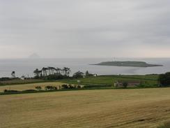
This walk starts off at the Seal Shore Camping and touring site in Kildonan. Leave the campsite and turn right to climb uphill along a road for a little over a mile, until it ends at a T-junction with the A814 road in Dippin. At the junction turn right to head northeastwards along the A418 road past Dippin Head and then continue along it as it sings to head northwards as the road descends into Whiting Bay. Continue along the road as it heads through the village and then climbs uphill out of the village, before descending down towards Lamlash. As this village is approached turn to the right down a footpath that descends down the hillside toward Cordon. When the footpath reaches a track turn right and follow this onto a junction with a road. Continue on to head northwards, and when the road turns to the left by a stream continue straight on along a path that lead over the stream before ending at the A418 road once again in Lamlash.
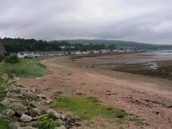
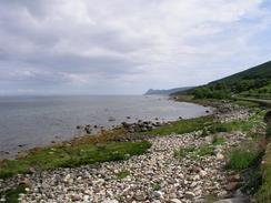
Turn right and follow the A418 northeastwards into Blairbeg, where it turns to the left to head northwestwards uphill before turning to head northwards as it descends down into Brodick. Follow the road through Brodick and continue on as the road crosses Glen Cloy and passes a school on the left. Immediately before a museum is reached on the right turn right down a footpath that immediately crosses Glenrosa Water on a footbridge before heading across a golf course and reaching the A418 once more. Turn right and follow the A418 as it heads past Brodick Castle and continues on to Merkland Point, where it turns to head northwards through Corrie and on onto Sannox. This walk ends at the Sannox Bay Hotel in the village.
Distances
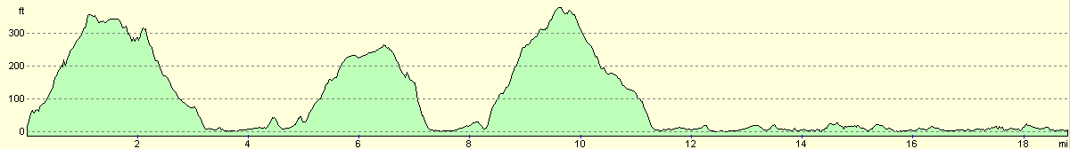
| From | To | Distance (m) | Ascent (ft) | Descent (ft) |
|---|---|---|---|---|
| Kildonan | Lamlash | 7.9 | 876 | 886 |
| Lamlash | Brodick | 3.6 | 446 | 436 |
| Brodick | Sannox | 7.4 | 299 | 302 |
This makes a total distance of 18.9 miles, with 1621 feet of ascent and 1624 feet of descent.
For more information on profiles, ascents and descents, see this page
Accommodation
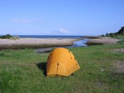
I put up my tent on a little path of green grass by Sannox Bay in Sannox, just down the road from the Sannox Bay Hotel. This was an absolutely superb place to spend the night, with the burn to my left and the views of Goat Fell to the right.
Disclaimer
Please note that I take no responsibility for anything that may happen when following these directions. If you intend to follow this route, then please use the relevant maps and check the route out before you go out. As always when walking, use common sense and you should be fine.
If you find any information on any of these routes that is inaccurate, or you wish to add anything, then please email me.
All images on this site are © of the author. Any reproduction, retransmissions, or republication of all or part of any document found on this site is expressly prohibited, unless the author has explicitly granted its prior written consent to so reproduce, retransmit, or republish the material. All other rights reserved.
Although this site includes links providing convenient direct access to other Internet sites, I do not endorse, approve, certify or make warranties or representations as to the accuracy of the information on these sites.
And finally, enjoy your walking!
This walk was mentioned in the following routes:
| My walk around the coastline of Britain |
Nearby walks
| # | Title | Walk length (miles) |
|---|---|---|
| 474 | Dougarie Point to Kildonan | 19.2 |
|
|

|