Walk #840: A circular walk from South Wonston to Chilbolton
 |
 |
|
General Data
| Date Walked | 07/09/2009 |
| County | Hampshire |
| Start Location | South Wonston |
| End Location | South Wonston |
| Start time | 08.51 |
| End time | 16.50 |
| Distance | 20.7 miles |
| Description | This was a long walk to the north of Winchester, following trackways and roads to form a circular walk. |
| Pack | Today I carried my 30-litre Karrimor rucksack, filled with waterproofs, a book and other odds and ends. |
| Condition | I am utterly knackered after this walk. I was sick twice just before the end, and my feet are utterly shot. It is the longest walk that I have done for at least six months, and it shows. |
| Weather | Today's weather was dominated by light, drizzly rain, which at times was fairly hard. It was not a particularly cold day, but the weather made it feel so. |
| OS map | Landranger number 185 (Winchester & Basingstoke, Andover & Romsey) |
 |
 |
|
 |
 |
|
Map of the walk
Maps courtesy of Google Maps. Route for indicative purposes only, and may have been plotted after the walk. Please let me have comments on what you think of this new format. For a detailed table of timings for this walk, please see the table file.
 |
 |
|
 |
 |
|
Notes
After all the chaos and loveliness of our wedding was over, I decided to get back to some, good, old-fashioned walking. I wanted to ease myself in gently - it had been six months since I last did a long walk - and so decided to do a fifteen or sixteen mile walk in my local area. All of my planned walks were at least twenty miles, so I quickly dreamt up a walk that would not involve too long a drive and break me in easily. I therefore set off on the (relatively) short drive to South Wooston. Unfortunately the M3 was stop-start, and therefore I reached the village later than I expected. It was the start of school as I drove along the main road in the village, and some soldiers from the nearby Worthy Down Camp were dropping off their children - their uniforms looking strangely odd amongst the mothers with pushchairs. I looked for somewhere to park, and more by luck than good judgment I came across a car park by the recreation ground. I parked up, got my kit together, and set off.
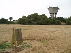
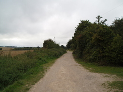
Initially I followed a track that ran westwards right along the southern edge of the village; off to the left were the race course cottages - was there a race course here at some time - and ahead a large concrete water tower, the V-shaped tank dominating the area. At one point there was a boundary stone beside the track. Soon I crossed the A34(T) on a high bridge, on the other side of which was the water tower. A trig pillar is marked on the map just to the south, and I continued along the track for a short distance before cutting across a field to reach the pillar. I got some good shots with both the pillar and the water tank in them.
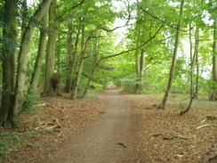
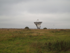
A little further along the track there was a solitary pillbox, some sides of which were overgrown. It seemed like a strange place to have one - was it to protect the drove? After this I reached the A272, and then another track that headed northwestwards. There is an oil installation marked on the map at the intersection of some tracks, but I saw no sign of it. The track entered some woodland, and I then took another track that headed across Brockley Warren, reaching the A30. After this a road headed on; I yomped along this a little as I was feeling fairly good. With hindsight, that was a mistake. After a little while I took another set of tracks that passed a Braithwaite tank, and then took me past the eastern edge of the old Chilbolton airfield. This was now dominated by the large radio telescope visible in the distance, seeming slightly out of place in the landscape.
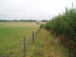
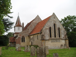
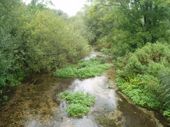
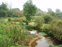
Road took me down into Chilbolton, where I extended the walk slightly by joining the Test Way and following this as it looped beside the river. Initially the path squeezes between a fence and a hedge, but then the views opened out. It was tempting to continue along the river, but instead I headed back into the village. The pub was not open, but the post office was, and I nipped in to buy a packet of crisps, some extra water and a couple of bars of chocolate. I munched on these as I continued through the village, passing some pretty thatched cottages to reach the church.
This was a classic Hampshire church, and I went into the churchyard for a few moments. Inside, near the gate, was a white stone commemorating Captain Richard John Holmes, who died in Iraq in 2006. It was a sad sight. A little further away was another gravestone in an altogether lighter note; it had a pleasant inscription and a picture of a motorbike; obviously the dead man had loved bikes. The difference between the simplicity of the soldier's stone and the fun in the motorcyclists was marked, yet love was evidently everywhere.
Roads took me on through Newton Stacey, and then towards the Moody Down danger area. Red flags were flying, showing that the ranges were in use, and I kept on along the road to reach a trig pillar at the top of the hill. This was one of the best-kept trig pillars that I have seen in a while - it had been painted white, and the grass on the verge surrounding it had been neatly trimmed. A little further on I reached the village of Barton Stacey. Off to the right there was a shop and pub - I went into the pub and sat down, chatting to the landlord as I supped a couple of pints. A couple were eating a meal beside me with their young baby, and I imagined myself and Sencan in a few years time.
I set off once more feeling slightly drunker, and I nipped into the shop to buy some more grub and water, I passed the church, and walked for five minutes before I realised I had taken totally the wrong road, having headed northwards towards the River Dever instead of eastwards. This was no real problem, and just before I reached the river I turned right along another road, which looped around to reach the road I should have been on.
As I headed east I started to feel slightly ill; having two pints in the pub had been a mistake, especially as it had been so long since my last walk. My feet were also aching a great deal, and I started limping. One of the problems with such a situation is that when you start limping you put more strain on your body, and that uses more energy and can cause other problems. Pretty soon my left knee was aching as well, adding to me misery.
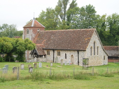
On a positive note, it was a pretty stretch of road. The small church at Lower Bullington was attractive, and so was the tiny River Dever; like all the chalk streams in this area, the water was crystal clear. Shortly afterwards I reached a viaduct that carried the old Winchester to Newbury railway line over the river, and then passed under the A34(T).
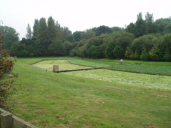
At Manor Farm it started to spit with rain, and I walked through this until it started to get heavier. I was starting to get soaked, so I stopped to put on my raincoat. Naturally enough, this was a signal for the rain to stop. Roads took me southwards, and I then took a bridleway that headed over a hill; near the bottom there was a stile, on which some conkers had been placed in a line. As the path hit a road in Hunton I talked to Sencan on the phone, and then headed on along the road. Off to the right were some watercress beds, and three people were cutting the watercress. This was the first time I had seen this, and it was fascinating to see the machines they used to do it.
I followed a road south from Stoke Charity; in a few places fresh watercress lay on the road, where it had been dropped from the back of lorries. The pain was increasing, and I was starting to feel queasy. After a while I had a decision to make; a short distance away to the left down a track was a trig pillar above the Wallers Ash railway tunnel that I wanted to visit. Despite my fatigue I turned off and headed down the stony Alresford Drove. There was a pig farm off to the right, and the stench of the pigs made me feel increasingly ill. When I reached the top of the tunnel I could see the railway line stretching off into the distance, and to my right was a large spoil heap, the soil and rock dug out from the tunnel. This was overgrown and steep, and I did not feel like climbing up it as I felt ill.
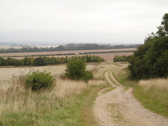
Instead, I headed back along the drove, all the time feeling increasingly queasy. Roads took me south for a short distance, and I then headed back along the Ox Drove track towards the car park. As it passed over the old railway line I started hiccoughing, and then, suddenly I was sick. My head started spinning and I rested on all fours. I continued on, heading on the wrong side of a hedge, forcing me to turn back to take the right path. Only then did I see a gap in the hedge that I could have got through. I was sick once more just before I reached the car. A group of teenagers were hanging around near my car, and they looked slightly perturbed by my rather dishevelled appearance. I used my little remaining water to swill out my mouth, which I spat out beside the car, right in the view of several people. Frankly, I was beyond caring.
This should not have been a difficult walk, yet, possibly due to my long lay-off from walking, it proved very difficult. Despite this, I enjoyed it in a rather perverse way. If nothing else, it was certainly memorable.
 |
 |
|
 |
Directions
This walk starts off from the car park at the recreation ground at the end of West Hill Road South. Leave the car park, and just before the tarmac starts turn left along a green lane called Lower Road. Head west along this until it ends at Christmas Hill road. Turn left for a few yards and then turn right, taking a track that heads off from a layby. This immediately crosses the A34(T) road on a bridge, and then passes a water tower on the left.
Continue along this track as it heads westwards until ending at the A272 road. Turn right along this to head northwestwards; after a quarter of a mile turn left along another track called Ox Drove. This soon crosses another road and continues on for nearly a mile to reach a complex junction of four tracks. Take the second track, heading slightly to the left of straight on, and follow this track as it curves to take a more westerly course. This track runs through trees; when a crossroads of other tracks is reached at SU426362 turn right to follow another track that heads northwestwards for a mile.
This track ends at the A30. Cross this, and continue straight on northwestwards along Martins Lane. This passes a caravan park at Stonefield Park, and then at SU404385 turn left along a track. This heads southwestwards for about a hundred yards; shortly after a water tower on the left turn right along another track. After four-fifths of a mile this track ends at Little Drove Road; turn left and follow this road for a hundred yards until Station Road leads off to the right. Follow this downhill for a third of a mile until it ends at Coley Lane.
Turn left along Coley Lane for a few yards until a bench is reached on the left, and then turn right, joining the Test Way. This footpath squeezes along with a fence on the right, before reaching a playing field. Keep on the Test Way as it exits the playing field and joins a track. As the Test Way heads off to the left, turn right along Joys Lane, which curves around to the right to end at a road in the village. Turn left and follow this road as it heads northeastwards through the village, passing the pub and the post office until a road junction is reached with a church on the left.
At this triangular junction turn right along Winchester Street, which curves around to the right. Take the first road off to the left and follow this for a little over half a mile until it reaches the B3420. Cross the B32420, and then continue on along another road that heads eastwards through Newton Stacey. After three-quarters of a mile the road juinks to the right and then the left, to head northeastwards with the Moody Down military range on the right. After a mile and a quarter this roads descends downhill and ends at a junction by the church.
Turn left and head northwards along a road for half a mile. Pass Manor House Farm on the right, and just before the River Dever is reached turn right along Roberts Road. This heads eastwartds before curving to the right to heads southwards with houses on either side of the road. This road ends at a T-junction with Bullington Lane. Turn left and follow this lane eastwards for 1.3 miles; it passes Lower Bullington Church on the left, then passes under an old railway viaduct and the A34(T) before ending at the A30 road. Turn right and then immediately left to follow a road eastwards. This crosses the River Dever and then curves to the right to head southwards past Norton Manor. When this reaches a crossroads take a footpath that heads off half-left. This climbs uphill, before descending to meet a road in Hunton. Cross this road and follow a footpath that soon ends at a driveway. Follow this driveway down to a road.
Turn left and follow this road eastwards; it curves to the right and crosses the River Dever to reach a crossroads in Stoke Charity. Continue straight on southwards along Old Stoke Road for nearly two miles. At SU484363 turn left along Alresford Drove for two-thirds of a mile, uintil you are above the northern portal of Wallers Ash tunnel. Then turn around and head back towards the road. At the road turn left and follow it southwards for a little under half a mile; when a junction with Ox Drove is reached on the right, turn right and follow the track westwards for a little over half a mile until the car park is reached on the left, where this walk ends.
Distances
| From | To | Distance (m) | Ascent (ft) | Descent (ft) |
|---|---|---|---|---|
| South Wonston | Chilbolton | 7.5 | 341 | 488 |
| Chilbolton | Upper Bullington | 6.0 | 361 | 325 |
| Upper Bullington | South Wonston | 7.2 | 390 | 279 |
This makes a total distance of 20.7 miles, with 1092 feet of ascent and 1092 feet of descent.
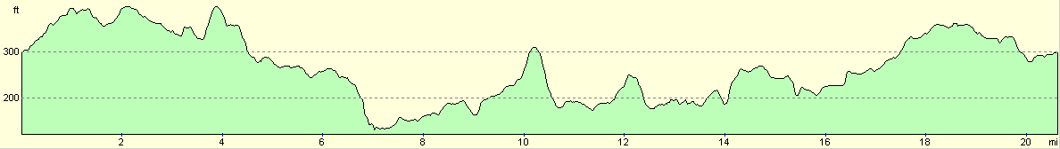
For more information on profiles, ascents and descents, see this page
Disclaimer
Please note that I take no responsibility for anything that may happen when following these directions. If you intend to follow this route, then please use the relevant maps and check the route out before you go out. As always when walking, use common sense and you should be fine.
If you find any information on any of these routes that is inaccurate, or you wish to add anything, then please email me.
All images on this site are © of the author. Any reproduction, retransmissions, or republication of all or part of any document found on this site is expressly prohibited, unless the author has explicitly granted its prior written consent to so reproduce, retransmit, or republish the material. All other rights reserved.
Although this site includes links providing convenient direct access to other Internet sites, I do not endorse, approve, certify or make warranties or representations as to the accuracy of the information on these sites.
And finally, enjoy your walking!
Nearby walks
| # | Title | Walk length (miles) |
|---|---|---|
| 709 | South Downs Way: Winchester to Wether Down | 20.4 |
| 787 | Romsey to Eastleigh via Winchester | 21.1 |
| 789 | A circular walk from Mottisfont to Fullerton | 21.4 |
|
|

|