Walk #556: Seaton House to Broughty Ferry
 |
 |
|
General Data
| Date Walked | 14/09/2003 |
| County | Tayside |
| Start Location | Seaton House |
| End Location | Broughty Ferry |
| Start time | 09.13 |
| End time | 16.28 |
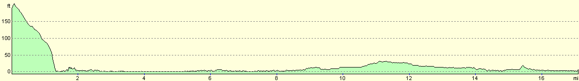
| Distance | 17.6 miles |
| Description | The first part of this walk was quite an enjoyable walk close to the sea, but the second part was spoilt slightly by the fact that I could not walk around Buddon Ness and had to take an inland route. |
| Pack | Today I carried my 30-litre Karrimor HotRock rucksack, which was filled with my packed lunch, waterproof leggings, water bottle and a couple of spare shirts, together with the usual assortment of odds and ends. |
| Condition | I had no significant problems during today's walk, but once I had finished I had more than a little pain from the underside of my left foot, which was probably brought on by the long road walk in my boots. |
| Weather | Today was yet another dry day, but there was cloud cover for most of it and this helped keep the temperatures down. The strong winds of yesterday continued, and as these were a headwind for most of the time they were quite annoying. |
| OS map | Landranger number 54 (Dundee & Montrose, Forfar & Arbroath) |
 |
 |
|
 |
 |
|
Map of the walk
Maps courtesy of Google Maps. Route for indicative purposes only, and may have been plotted after the walk. Please let me have comments on what you think of this new format. For a detailed table of timings for this walk, please see the table file.
 |
Notes
My bladder awake me at five thirty, and instead of going back to bed I decided to get up and start working. Due to this I got most of my work done before eight, and this was just in time for Sam to get up and start making some delicious pancakes for breakfast. Before I set off on the walk I explored the campsite for a while - it has some interesting structures on it that I enjoyed looking at. I also found another way out of the campsite that would save me having to go over the wall and barbed wire that I had to scale to get into the campsite last thing on yesterday's walk. This made the first part of the walk much more enjoyable, as it allowed me to walk along a good track along the outside of the wall enclosing the campsite rather than through the fields on the other side.
I had intended to walk from the campsite down towards Needle E'e, but the death of a young girl there yesterday made me want to avoid it so I headed down the road to the seafront. When I got there I had a phone call from a local radio station, Wave 102, who wanted to do an interview with me. It was fairly windy so I jogged to some covered seats on the seafront. I sat down on one that was sheltered from the wind, but instantly found (by both small and he sensation of damp) that I had sat down in a pool of pee on the seat. Trying not to swear down the phone line (I was on hold to the radio station whilst a song was playing) I went down to another seat for the interview.
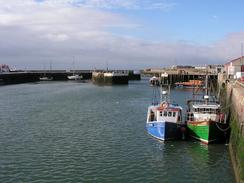
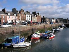
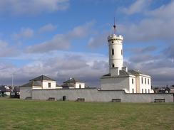
I must admit that I quite liked Arbroath. I had wanted to try Arbroath Smokies, one of its local delicacies (freshly caught, cleaned and salted haddock, smoked in barrels over an oak-chip fire), but none of the shops were open when I passed, which was a disappointment. I could not even smell the smoke, which again I expected to be hanging over the town. I passed the signal tower, built in 1818, which was the shore station for the Bell Rock Lighthouse, which was constructed by Stevenson between 1807 and 1811. It was quite an interesting building and is now a museum, although it was not open when I passed by. The harbour area was also quite nice, and I enjoyed looking around at the boats moored in it.
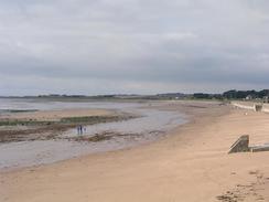
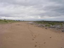
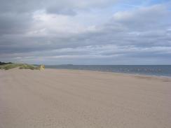
The walk from Arbroath to Carnoustie was along the beach, which made for quite a nice walk. After a couple of miles the sandy beach ended and was replaced by a rocky foreshore, but near the top of this there were stretches of sand that made the going easy enough. Just over the top of he little sand dune was the main Edinburgh to Aberdeen railway line, and occasionally I could hear train speeding past, although the ridge of sand prevented me from seeing them. At East Haven there is a little sandy harbour that I could walk around before continuing on into Carnoustie.
I kept a coastal route around Carnoustie before meeting Sam at the car park next to the station in the town. The Italian grand prix from Monza was due, and so for an hour and a half I watched the preliminaries and the start, but the race was boring and so I decided to leave before the end. I had hoped that I would be able to walk along the sands to Buddon Ness and then around to Monifieth from there, but the area is dominated by an army base and red flags were flying. To reinforce the matter occasionally there was the sound of gunfire coming over the water from the ranges, and so I new that I would have to create an inland route to get to Monifieth. On the map I could see some tracks running past the railway station at Barry Links and on past the Barry Buddon Camp.
The first part of the track took me past the world-famous Carnoustie golf course, and marquees and scoreboards were being erected, and power cables strung out, so I an only assume that some sort of competition is coming to the course. Eventually I reached Barry Links Station, where I found that the track onwards was over prohibited land so I had no choice but to head north to meet the A930 road in Barry. The walk to Monifieth was fairly boring and not a nice walk, which was a shame after the lovely walk this morning, but when I entered the town it became better with a pavement.
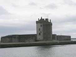
The final stretch of the walk took me along paths behind the foreshore southwestwards to Broughty Ferry and the nice Broughty Castle, a very nice-looking castle that is now a museum. On the way down there I chatted to a nice local lady for twenty minutes as we walked, and people gave me donations - which is always a nice and humbling feeling. Sam was waiting for me about a mile northwest of the town, and I was glad to stop despite the fact that it had only been a short day's walk.
One of the things that has surprised me on this walk is how little I have had to use my compass; I am not even sure where it is at the moment; it is probably packed away in my rucksack. When I do need to walk on a heading the rudimentary moving compass on my GPS unit does well; however this has not been needed very often as for much of the time it has simply been a case of keeping the sea on my left. The routes up the only mountains that I have done on the trip - Snowdon, Scafell Pike and Ben Nevis - were all straightforward, and I did not really need my compass for them.
Directions
This walk starts off at the campsite at Seaton House, to the northeast of Arbroath. Leave the caravan park by the main gateway and then immediately turn left, to walk southeastwards down a track with the wall of the park to the right. The track ends at a crossroad by East Seaton Farm; here turn right and walk southwestwards down a public road that soon turns to the left and then the right, passing through West Seaton before reaching the seafront near Whiting Ness. Turn right and follow a promenade westwards beside the road into the centre of Arbroath. When the promenade ends continue on towards the harbour along minor roads. Pass the harbour, and then continue on westwards along a promenade. When this ends, drop down onto the beach and follow this southwestwards past Elliot.
After a couple of miles the beach ends and the foreshore becomes rocky, but I found that it was still easy to walk southwestwards along the high-tide line past East Haven and on into Carnoustie. I continued along he foreshore until I got adjacent to the railway station, when I turned to the right and walked to the station car park. As the red flags were flying on the Buddon Ness naval range I followed a track westwards beside the railway line that soon passed various golf club houses, and then passed the golf courses themselves, always being close to the railway line. At Barry Links railway station I turned to the right along a road that crossed over the railway line at a level crossing and continued northwards and northwestwards for a little over a kilometre until it ended at the A930 road.
Turn left and follow the A930 road as it heads southwestwards, passing a golf course on the left before entering Monifieth. When the golf course ends turn left down a road that heads southwestwards back towards the railway line. The road then curves around and passes the railway station before rejoining the A930 road. Turn left and follow the A930 for a few hundred yards as it curves to the right, and then turn to the left down a road that leads to a walkway behind the beach. Turn right and follow this walkway southwestwards through Barnhill and on until ends at Broughty Castle. Walk north of Broughty Castle and then follow a road that skirts the coast past the lifeboat station and on northwestwards. This walk ends at the northwestern end of Fisher Street, a little over a kilometre from the castle, just before the road passes over the railway line.
Distances
| From | To | Distance (m) | Ascent (ft) | Descent (ft) |
|---|---|---|---|---|
| Seaton House | Arbroath | 2.5 | 33 | 217 |
| Arbroath | Carnoustie | 6.6 | 66 | 66 |
| Carnoustie | Broughty Ferry | 8.5 | 112 | 112 |
This makes a total distance of 17.6 miles, with 211 feet of ascent and 395 feet of descent.
For more information on profiles, ascents and descents, see this page
Accommodation
We parked for the night at the northwestern end of Fisher Street, just out of the centre of Broughty Ferry. This was a reasonable place to spend the night, with some shops nearby and some great views over the Tay towards the bridges and Tayport.
Disclaimer
Please note that I take no responsibility for anything that may happen when following these directions. If you intend to follow this route, then please use the relevant maps and check the route out before you go out. As always when walking, use common sense and you should be fine.
If you find any information on any of these routes that is inaccurate, or you wish to add anything, then please email me.
All images on this site are © of the author. Any reproduction, retransmissions, or republication of all or part of any document found on this site is expressly prohibited, unless the author has explicitly granted its prior written consent to so reproduce, retransmit, or republish the material. All other rights reserved.
Although this site includes links providing convenient direct access to other Internet sites, I do not endorse, approve, certify or make warranties or representations as to the accuracy of the information on these sites.
And finally, enjoy your walking!
This walk was mentioned in the following routes:
| My walk around the coastline of Britain |
Nearby walks
| # | Title | Walk length (miles) |
|---|---|---|
| 555 | Kirkside to Seaton House | 22.1 |
| 557 | Broughty Ferry to Errol | 16.5 |
|
|

|