Walk #526: Hope to Bettyhill
 |
 |
|
General Data
| Date Walked | 13/08/2003 |
| County | Highlands |
| Start Location | Hope |
| End Location | Bettyhill |
| Start time | 09.11 |
| End time | 18.00 |
| Distance | 23.5 miles |
| Description | This was a varied and quite pleasant walk, along a combination of moorland, roads and footpaths. |
| Pack | I used my new Highlands water hydration pack, which contained a two-litre water bottle, some spare batteries and a couple of chocolate bars. |
| Condition | I feel absolutely fine after this walk, and have no significant problems to report. My toes ached a little again today, and I spent some time strapping them up. |
| Weather | The weather today was the worst for some time. I awoke to the van being rocked by heavy gusts of rain, and there were occasional heavy showers of rain. When I left Mervan there was a lovely rainbow in the distance, and although there were some sunny periods there were also some prolonged periods of rain, particularly in the afternoon. The strong winds made this much worse, although fortunately it was mostly coming from behind me. |
| OS map | Landranger number 9 (Cape Wrath, Durness & Scourie) and Landranger number 10 (Strathnaver, Bettyhill & Tongue) |
 |
 |
|
 |
 |
|
Map of the walk
Maps courtesy of Google Maps. Route for indicative purposes only, and may have been plotted after the walk. Please let me have comments on what you think of this new format. For a detailed table of timings for this walk, please see the table file.
 |
 |
|
Notes
I woke up this morning to the van rocking in the gusting wind, and to rain drumming on the roof above my head. This did not bode well, although I knew that I could not really complain as I have had a week or so of glorious weather. Unfortunately I had intended to walk up to Whiten Head first thing this morning, and I really did not fancy doing the rough moorland walk in the wind and rain. This was a difficult decision and I prevaricated for longer than I really should have, but another rain shower convinced me to walk along the road to Tongue instead of walking round the cliffs. When I set off I was greeted with a lovely rainbow hanging over the road to the west, a beautiful sight that I stood and watched for a couple of minutes. I followed the road as it descended down to the bridge over the River Hope, and onwards as it climbed steeply uphill. The sun was shining at this point and I was very tempted to leave the road and follow my planned route across the moorland to Whiten Point, but I was wearing trainers and did not have my walking poles. This was a good thing, as a few minutes later it started to rain, as the wind blew from behind and carried the wind nearly horizontally into my back. The wind was actually quite chilling, and I was glad when the rain stopped and the sun started shining one again.
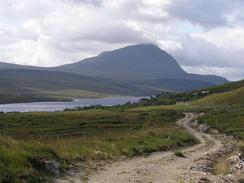
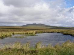
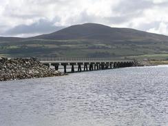
The walk eastwards along the road took me past some fairly wild moorland, with some small lochs. It was beautiful scenery, especially with some mountains visible in the distance. I passed the ruins of Moine House, which is in an extremely exposed but beautiful position. The road then started a slow and plodding descent down to the causeway over the Kyle of Tongue, which is quite an impressive structure built in 1971. Halfway across I stopped in a car park to take some photos, and ended up chatting to a couple for five minutes about the walk - they are touring the northwest of Scotland and, strangely enough, were British. I say this because the vast majority of the motorhomes and cars that I have seen over the last few days have been German, Dutch or Spanish, and indeed it seems like half the vehicles on the road are motorhomes.
I met Sam for lunch in a lay-by near the phone box in Coldbackie. I was quite chilled after the wild weather, and so Sam made me a coffee and some mushroom soup to help me warm up. This worked quite well, and I was in a happier mood one I had eaten it all. The next stretch of the walk was going to be along what I believed to be pathless moorland, and so I had to change from my trainers into my boots. A couple of toes on my right foot had been hurting this morning, and so I used the opportunity to bind them up to see if it would help. Fortunately it did, and they gave me no more trouble once I restarted the walk.
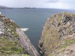
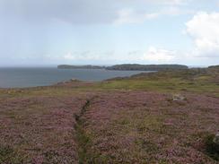
There was no path marked on the map for the next stretch of the walk, but I found a good one on the ground that took me along the cliffs towards the ruined croft at Sletell. The existence of the path made the walk much more enjoyable than it would otherwise have been, especially as the rain was lashing down on me as I walked. From Sletell there is a path marked on the map, but I took an obvious path on the ground that followed the cliffs around before eventually descending down into Port an t-Strathain. A quick climb and descent from there took me into the beautiful little Lamigo Bay, where I joined the road.
In Achtory I came across a small but fascinating little museum in one of the cottages, and I spent a few minutes quickly scanning the displays about the history of the area. A few doors down was the local post office / shop, and I ended up chatting to a couple of ladies in there, who kindly gave me a donation for the charity. Outside the houses in the village were piles of peat drying out over the summer, showing that peat burning is still in vogue in this area. Over the last couple of days I have seen something that I have not seen for a couple of days - fields. Around Bettyhill there were circular bails of hay in enclosed fields, the first proper arable fields that I have seen since the Campbletown area.
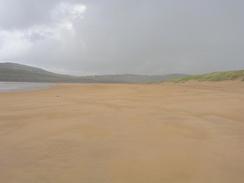
The day ended with a long and nice walk along the beach past Torrisdale Bay and a walk up and down the River Borgie into Bettyhill, where Sam was waiting for me in Mervan in the car park in the village. The walk along the beach would have been lovely in good weather, but with the rain lashing down onto me it was quite depressing. This and the fact that I did not do the route that I wanted to do made me quite depressed, and I can only hope that the weather is better for tomorrow's walk.
Directions
This walk starts off in a lay-by off the A838 road on the hillside to the west of the village of Hope. Join the A838 road and follow it as it heads downhill to the east, reaching a bridge over the River Hope, after which the road climbs uphill over moorland. It continues eastwards past some areas of woodland and past Loch Maovally and the ruins of Moine House. After this the road starts a slow descent for a couple of miles until it reaches the western end of the causeway over the Kyle of Tongue.
Walk the mile over the bridge and as soon as the astern side of the bridge is reached turn left along a road that skirts the foreshore before climbing uphill to join the A836 road. Turn left and follow the A863 road northeastwards for over a mile into Coldbackie. A few yards past the phone box in the village turn left along a path, and after a few yards turn right down a grassy track towards a house. Just before the house is reached turn left along a path that leads down to a bridge over a stream, and follow the path uphill on the other side until it ends at a T-junction with a track. Turn left and follow this track northwards until it ends at a road.
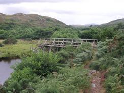
Join the road and follow it northwards through the little hamlet of Skullomie until the road ends by a cottage. Continue on through a little gate onto moorland. a distinct path (not marked on the map) leads northeastwards, not on the cliff edge but a shot distance inland, for a couple of miles to three ruined buildings at Sletell. From Sletell there is a path marked on the map that heads eastwards, but I ended up following a clifftop path that eventually descends down to the beach at Port an t-Strathain. A little footbridge takes you over the Alltan Dearg, and I climbed uphill to the east to a little white cottage. From here I joined a track that heads eastwards towards another cottage, and then descended steeply to Lamingo Bay. Climb up the other side for a short distance until a path is reached, and then turn right along the path that eventually lead to a little cottage.
At the cottage join a road and follow it southwards for a couple of hundred yards until it ends at a T-junction by a phone box. Turn left at this junction and follow it in a rough easterly direction until it ends at a T-junction with a road in Clasheddy. At this junction turn right and follow the road southeastwards, passing a church and a phone box before meeting the western edge of Torrisdale Bay. Continue on as the road climbs up a light hill, and then drop down a path that leads to a bridge over the River Borgie. On the other side of the bridge follow a path that heads northwards past a series of sand dunes and onto the beach by Torrisdale Bay. Follow the beach eastwards, and then when the beach ends by the channel of the River Naver turn right and walk south along the bank of the river until a bridge that carries the A836 road over the river is reached. Turn left and cross the bridge, and then follow the road as it heads northwards up the eastern bank of the river for a mile into Bettyhill. This walk ends in a car park opposite the Bettyhill Hotel in Bettyhill.
Distances
| From | To | Distance (m) | Ascent (ft) | Descent (ft) |
|---|---|---|---|---|
| Hope | Coldbackie | 11.4 | 1280 | 1211 |
| Coldbackie | Bettyhill | 12.1 | 1716 | 1719 |
This makes a total distance of 23.5 miles, with 2996 feet of ascent and 2930 feet of descent.
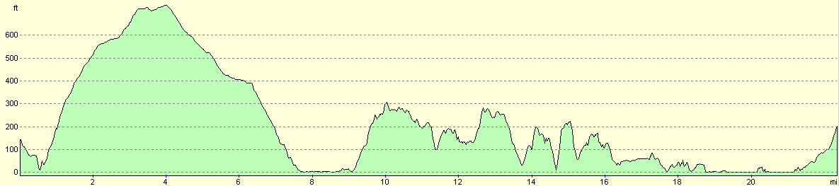
For more information on profiles, ascents and descents, see this page
Accommodation
We parked for the night in the car park opposite the Bettyhill Hotel in Bettyhill. This was very handy for the pub and the public toilets, and was a fairly quiet place to spend the night.
Disclaimer
Please note that I take no responsibility for anything that may happen when following these directions. If you intend to follow this route, then please use the relevant maps and check the route out before you go out. As always when walking, use common sense and you should be fine.
If you find any information on any of these routes that is inaccurate, or you wish to add anything, then please email me.
All images on this site are © of the author. Any reproduction, retransmissions, or republication of all or part of any document found on this site is expressly prohibited, unless the author has explicitly granted its prior written consent to so reproduce, retransmit, or republish the material. All other rights reserved.
Although this site includes links providing convenient direct access to other Internet sites, I do not endorse, approve, certify or make warranties or representations as to the accuracy of the information on these sites.
And finally, enjoy your walking!
This walk was mentioned in the following routes:
| My walk around the coastline of Britain |
| My sectional Land's End to John O'Groats walk |
Nearby walks
| # | Title | Walk length (miles) |
|---|---|---|
| 524 | Kearvaig to Durness | 23.8 |
| 525 | Durness to Hope | 20.1 |
|
|

|