Walk #521: Duartbeg to Rhiconich
 |
 |
|
General Data
| Date Walked | 07/08/2003 |
| County | Highlands |
| Start Location | Duartbeg |
| End Location | Rhiconich |
| Start time | 10.27 |
| End time | 16.01 |
| Distance | 14.9 miles |
| Description | This was a relatively short road walk, through some nice scenery. |
| Pack | Today I carried my 30-litre Karrimor HotRock rucksack, which was filled with my packed lunch, waterproof leggings, water bottle and a couple of spare shirts, together with the usual assortment of odds and ends. |
| Condition | I feel absolutely fine after this walk, and could easily have walked further if I had needed to. My neck and shoulder were again fine, which is a good sign as I will have to carry a heavy rucksack from tomorrow afternoon. |
| Weather | The day started off with a fairly heavy mist, which took until midday to lift. After this the sun predominated with few clouds, but it never got quite as hot as it did yesterday, and there was more of a breeze to help cool me down. |
| OS map | Landranger number 9 (Cape Wrath, Durness & Scourie) |
 |
 |
|
 |
 |
|
Map of the walk
Maps courtesy of Google Maps. Route for indicative purposes only, and may have been plotted after the walk. Please let me have comments on what you think of this new format. For a detailed table of timings for this walk, please see the table file.
 |
Notes
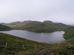
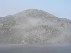
When I opened the blinds this morning I was greeted with an unexpected sight - mist. It lay thickly over the campsite, and it even obscured the beach a short distance away. As I had mains power to Mervan I decided that I would do some work on the website, hoping that the delay would give the mist a chance to lift. Unfortunately by ten o'clock it was still present, and so we packed Mervan up and drove back to Duartbeg.
The initial stretch of the walk from Duartbeg to Scourie was a very straightforward road plod, which was slightly spoilt by the fact that the surrounding hillsides were wreathed with mist. I sped along, and descended into Scourie to meet Sam by the shop. It had been my intention to walk northwards from the village over a rough path to Tarbet, but due to the mist I decided to confine along the road. This was a hard and surprisingly depressing decision, as I had been looking forward to walking that path due to the views - views that would have been obscured by the mist.
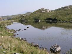
Forty minutes after I left Scourie the mist started to lift, and was soon replaced by bright sunshine. This made the walk quite nice, and the only steep ascent, about a mile out of Scourie, was easy. I stopped to have my lunch at Laxford Bridge, which is an absolutely superb spot. I stood with a couple of other people and watched a few dozen salmon swimming around in the pool under the bridge - a marvellous sight.
The rest of the walk to Rhiconich was along the fairly boring A894 road. This long plod was enlivened slightly by the road cuttings, which exposed nice cross-sections of the geological history of the area. To help interpret these cuttings there was a nice board, explaining the way the granite and dolerite had been intruded into the surrounding grey gneiss. It was tempting to extend the walk by walking to Skerricha and then around the peninsular between Loch Laxford and Loch Inchard, but I am in a hurry to get to Cape Wrath and that section of coastline does not appear to be very stunning on the map.
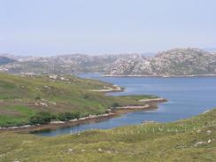
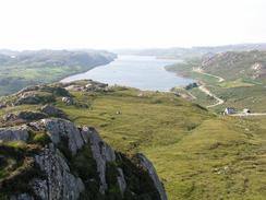
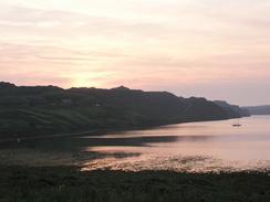
I arrived at Rhiconnich quite early, and I strode into Mervan not feeling in the least fatigued. Sam had arranged with the policemen in the small police station for us to park Mervan outside it, and this was ideal for the pubic conveniences and the hotel. I sat down for an hour or so, and then we went up a little hill behind the hotel for a very short walk. Sam stopped on a subsidiary top, and I continued on to a spot where I could take a panoramic photograph of the nearby mountains, including Foinaven and Arkle. This will probably not turn out very well as the sky was quite hazy, but it was worth the walk for the view that was fairly spectacular. In one direction were the high mountains, and in the other was Loch Inchard, glistening brightly in the sunshine.
I have got a short walk to do tomorrow, initially walking as far as Kinlochbervie, Oldshoremore and Blairmore, where I shall be meeting up with Sam. Tonight we packed up our large rucksacks, and at Blairmore I will transfer the contents of my little rucksack into the larger one and get ready for the last part of the walk to Sandwood Bay, where we wile be camping overnight. I am really looking forward to reaching Sandwood Bay again, and having Sam with me there will make it extra special.
Directions
This walk starts off at the junction of the road from Duartbeg and the A894 road. Join the A894 and follow it northwards past the house at Gaisgeil and then north-westwards for a mile to Lower Badcall, where there is a hotel. The road then heads steeply uphill to the north before swinging westwards and the northwards alongside the Loch an Daimh Mor.
The road swings around to the west once more before passing an aerial and turning to the right to start the descent down into Scourie. After about a mile the hotel is reached in Scourie, which is at the eastern end of the village. Follow the A894 eastwards as it leaves the village, passing some public conveniences before meeting the western end of Loch a' Bhadaidh Daraich.
Continue on along the A894 for about a mile along the southern end of the loch. Shortly past this the road starts to curve to the north, climbing up a steep hill as it does so. At the top of the hill the road curves to the Northeast and continues for a little over a mile to the Loch s' Bhagh Ghanmhich.
The road follows the western and eastern sides of this loch before continuing on to the Northeast to meet Loch na Claise Fea'rna. About five hundred metres beyond the northeastern point of the loch the road curves around to head southeastwards for about three kilometres. In doing so it descends and passes the little hamlet at Badnabay and the marshy area of Traigh Bad na Baighe.
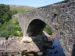
Eventually the junctions of the A894 and A838 roads is met. Turn left to follow the A838 northwards across Laxford Bridge as the road turns into a narrow single carriageway. The road then heads northwestwards along the northern side of Laxford Bay. The road then becomes two carriageways once more and starts to turn to a northeasterly heading, ascending steeply as it does so.
At the top of the hill the road skirts the eastern side of Loch na Fiacail and continues north-eastwards. The road crosses another loch on a causeway before turning to head northwards for a mile. The road then turns to a south-north-easterly heading, passing the road junction for Ardmore on the way, and descends downhill to the hotel at Rhiconich, which is at the south-eastern end of Loch Inchard.
Distances
| From | To | Distance (m) | Ascent (ft) | Descent (ft) |
|---|---|---|---|---|
| Duartbeg | Scourie | 3.8 | 469 | 584 |
| Scourie | Laxford Bridge | 6.6 | 709 | 719 |
| Laxford Bridge | Rhiconich | 4.5 | 814 | 781 |
This makes a total distance of 14.9 miles, with 1992 feet of ascent and 2084 feet of descent.
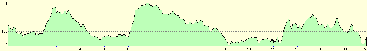
For more information on profiles, ascents and descents, see this page
Accommodation
We spent the night in a little lay-by beside the police station in Rhiconich, which is opposite the Rhiconich Hotel. The police officer (who lives in the station) very kindly allowed us to stay there.
Disclaimer
Please note that I take no responsibility for anything that may happen when following these directions. If you intend to follow this route, then please use the relevant maps and check the route out before you go out. As always when walking, use common sense and you should be fine.
If you find any information on any of these routes that is inaccurate, or you wish to add anything, then please email me.
All images on this site are © of the author. Any reproduction, retransmissions, or republication of all or part of any document found on this site is expressly prohibited, unless the author has explicitly granted its prior written consent to so reproduce, retransmit, or republish the material. All other rights reserved.
Although this site includes links providing convenient direct access to other Internet sites, I do not endorse, approve, certify or make warranties or representations as to the accuracy of the information on these sites.
And finally, enjoy your walking!
This walk was mentioned in the following routes:
| My walk around the coastline of Britain |
Nearby walks
| # | Title | Walk length (miles) |
|---|---|---|
| 198 | Inchnadamph to Kylesku | 10.2 |
| 199 | Kylesku to Scourie | 11.3 |
| 200 | Scouriemore to Rhiconich | 11.0 |
|
|

|