Walk #451: Auchenmaig to New England Bay
 |
 |
|
General Data
| Date Walked | 23/05/2003 |
| County | Dumfries and Galloway |
| Start Location | Auchenmaig |
| End Location | New England Bay |
| Start time | 10.53 |
| End time | 17.54 |
| Distance | 20.0 miles |
| Description | This was a fairly boring walk, all of which despite the first couple of miles was along roads. |
| Pack | Today I carried my 30-litre Karrimor HotRock rucksack, which was filled with my packed lunch, waterproof leggings, water bottle and a couple of spare shirts, together with the usual assortment of odds and ends. |
| Condition | I had a rip-roaring headache at the end of the walk, and despite from this I had no other significant problems to report. My right shoulder ached a little later on in the day, the first time that this has ached for a few days. |
| Weather | The morning was quite dry, and there was even some sunshine early on. Unfortunately as the morning went on the clouds started to gather, and it started to rain. Although this rain was not heavy as it has been on occasion over the last few days, and there were occasional short breaks in it, it was heavy enough and came head-on for most of the time. There was a fair amount of wind when I was on the cliffs near the beginning of the walk, but this was far less noticeable when I was at lower levels. |
| OS map | Landranger number 82 (Stranraer & Glenluce, The Rhins) |
 |
 |
|
Map of the walk
Maps courtesy of Google Maps. Route for indicative purposes only, and may have been plotted after the walk. Please let me have comments on what you think of this new format. For a detailed table of timings for this walk, please see the table file.
Notes
I had a late start today as I spent some time creating a CD that I could send to Terry to update the website with. This always takes a fair amount of time, and so I set off much later than I had been intending to. This worked out very badly, as the morning was much drier than the afternoon and I therefore missed the driest part of the day. The rain was absolutely awful today, and was thoroughly depressing as I plodded along the road. The rain was mostly coming straight in towards my face, and I even tried wearing my balaclava to keep my face warm and dry, the first time that I have worn it for months.
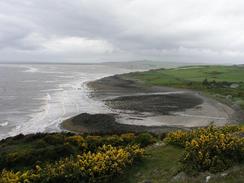
I was quite unsure about whether I could walk along the Luce Sands or not. These sands are used as part of a firing and bombing range, and next-door are the golf ball radars at the West Freugh airfield, site of one of the more infamous UFO sightings in Britain, which occurred in 1957. As I approached the area I could see no obvious red flags or lights, and no UFOs either, for that matter, but I decided to walk around the Luce Sands anyway. If I tried to go across the sand and then found that I could not progress I would have to make a big diversion back again. Whilst the weather was bad I also preferred to stay on the roads, as I prefer walking along roads rather than cross-country in the rain. This is one of the strange problems that I am finding with Scotland; because you can essentially walk anywhere you like, and so not have to stick to public right of ways as you do in England and Wales, I have to think much more about where I am going to walk. In many places following the coast is unfeasible, so I have to pick a more inland route, and I expect this situation to get worse as the walk goes on and I get to more remote areas.
It had been my intention to try and reach Drummore tonight, but as I was walking down the road Sam drove past me. The rain was still falling, I had a big headache forming, and as I had done twenty miles for the day I decided to end earlier than I had been planning. I think that this was a good idea, as I was very wet and more than a little fed up. I felt lower than I have been for some time, and all I could think about was getting dry and having a nice, warming cup of coffee. It is a shame that I was feeling so low, as I have been walking quite well over the last few weeks and covering some nice distances each day. It is very important to keep myself mentally happy on this trip, so I hope that I feel better soon.
Near the end of today's mark I reached the 4,000 mile mark on the trip. This is quite an amazing feeling, although I still have another 1,800 miles to go to reach Edinburgh. I have been making very good progress over the last few days, and I hope that I can keep this up for as long as possible. Tomorrow, however, I potentially have a lot of off-road walking to do if I want to stick to the coast, although if the weather is bad yet again I may just stick to the roads and tracks.
As soon as we parked Mervan in Drummore I stripped off my wet coat and over trousers, and then stripped off my underclothes, which were damp rather than wet. I had a really heavy headache, mostly at the front on the right-hand side of my head, and so I was forced to take a couple of tablets, which fairly quickly started to work. Sam had bought a bottle of champagne to celebrate having completed 4,000 miles, and we drunk this with the lovely meal that Sam cooked. It was a nice, if low-key, way to celebrate, and for the first time on the trip I actually feel as if reaching Edinburgh and completing the walk is possible. I have about 1,800 miles still to complete, which in a curious way does not seem that far, particularly when I think how far I have already walked. I also find it quite amusing to think that if I had been taking ferries I would be only 500 miles from the finish (most people who walk the coastline complete around 4,500 miles - my route is quite a bit longer).
Later this evening we went out to the pub opposite where we parked, the Ship Inn. I left at about ten thirty after having a good natter, and I was totally knackered. Sam stayed on, and as I did not have my keys with me I used Sam's, and left the door unlocked. In the past Sam has come in late and clambered over me to get into bed without my waking up, so when I woke up at about one to go to the toilet I realised that the door was unlocked. In my half-asleep state I did not realise that Sam was not back, and so I locked the door. I went back to sleep, and half an hour later I was woken up by Sam knocking on the door. I could not believe that I had not realised that she had not yet arrived back when I locked the door!
Directions
This walk starts off at the car park of the Cock Inn in Auchenmaig. Initially you have two choices to gain the track that heads up the Mull of Sinniniess; either walk westwards along the beach and then turn right to join the track in the field; or walk northwards along the A747 road for a few hundred yards until a road leads off to the left. Turn left along this road and follow it as it turns to the right and then the left. Immediately after the left-hand bend turn left down a track that heads southwards back to the sea. Once it meets the sea it turns to the right and the other route described joins here.
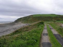
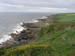
The track curves to the right below the Mull of Sinniness, and shortly after this bend a path leads uphill to the left. This is a well-marked footpath, although dogs are not allowed along it. Follow the path as it climbs up along the cliffs; the path is quite distinct and well marked with posts. It then descends to pass the farm at Laigh Sinnininess before continuing on as it slowly curves to head northwards and descends to meet a bend in a road at Stairhaven.
Join the road and follow it northwards for a couple of miles until it ends at the A75(T) road. Turn left along the A75(T) and follow it carefully (it is a busy road) for two miles westwards over the Water of Luce. Once the junction with the B7084 road is met turn left and follow this road past the junction with the B7077, where it turns to head southwestwards to pass West Freugh Airfield, until it meets the A716 road. Head southwestwards down the A716 for about half a mile, and when a road leads off to the left to enter Sandhead follow it through the village and then out on the other side to rejoin the A716. Head south down the road for another five miles, passing through Dyemill and Ardwell before the road rejoins the coast at New England Bay. This walk ends at the car park by the picnic area at the southern end of New England Bay.
Distances
| From | To | Distance (m) | Ascent (ft) | Descent (ft) |
|---|---|---|---|---|
| Auchenmaig | Sandhead | 14.3 | 902 | 909 |
| Sandead | New England Bay | 5.7 | 308 | 312 |
This makes a total distance of 20.0 miles, with 1210 feet of ascent and 1221 feet of descent.
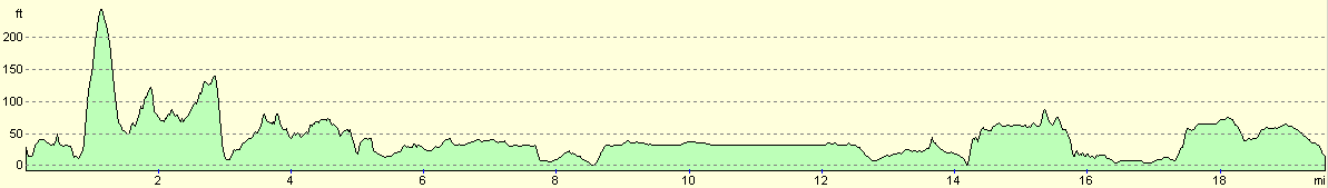
For more information on profiles, ascents and descents, see this page
Accommodation
There was nowhere for us to park at New England Bay, so we drove down to Drummore and parked opposite the Ship Inn, and near the slipway down onto the foreshore. This was very handy for the pub, which we took good advantage of later on in the evening. There were some public toilets nearby, but we did not need to explore to see if they were clean or not.
Disclaimer
Please note that I take no responsibility for anything that may happen when following these directions. If you intend to follow this route, then please use the relevant maps and check the route out before you go out. As always when walking, use common sense and you should be fine.
If you find any information on any of these routes that is inaccurate, or you wish to add anything, then please email me.
All images on this site are © of the author. Any reproduction, retransmissions, or republication of all or part of any document found on this site is expressly prohibited, unless the author has explicitly granted its prior written consent to so reproduce, retransmit, or republish the material. All other rights reserved.
Although this site includes links providing convenient direct access to other Internet sites, I do not endorse, approve, certify or make warranties or representations as to the accuracy of the information on these sites.
And finally, enjoy your walking!
This walk was mentioned in the following routes:
| My walk around the coastline of Britain |
Nearby walks
| # | Title | Walk length (miles) |
|---|---|---|
| 450 | Isle of Whithorn to Auchenmalg | 22.1 |
| 452 | New England Bay to Port Logan | 20.9 |
| 453 | Port Logan to Portslogan Farm | 19.5 |
|
|

|