Walk #436: Gosforth to Parton
 |
 |
|
General Data
| Date Walked | 08/05/2003 |
| County | Cumbria |
| Start Location | Gosforth |
| End Location | Parton |
| Start time | 08.33 |
| End time | 19.10 |
| Distance | 20.3 miles |
| Description | This was a highly enjoyable walk, although hard underfoot in places on the long stretches of shingle. It is also good that I seem to have recovered from my twisted ankle, and that I managed this walk with no problems. |
| Pack | Today I carried my 30-litre Karrimor HotRock rucksack, which was filled with my packed lunch, waterproof leggings, water bottle and a couple of spare shirts, together with the usual assortment of odds and ends. |
| Condition | My right ankle, which I twisted the day before yesterday, has recovered well and did not give me any trouble today. My left ankle ached at times, but aside from this I had no other problems, which I am glad about. |
| Weather | There was a great deal of rain overnight, and the morning dawned cloudy and windy. The cloud soon disappeared to be replaced with sunshine, but the winds continued on for most of the day, although they were less severe in the afternoon. |
| OS map | Landranger number 89 (West Cumbria, Cockermouth & Wast Water) |
 |
 |
|
 |
 |
|
Map of the walk
Maps courtesy of Google Maps. Route for indicative purposes only, and may have been plotted after the walk. Please let me have comments on what you think of this new format. For a detailed table of timings for this walk, please see the table file.
 |
 |
|
| |
 |
|
Notes
I took yesterday off, as when I woke up in the morning I found that I could not walk very well at all, and whenever I put weight on my right foot I had intense pain in it. Instead of risking doing a walk (I doubt I could really have done one in reality) I decided to take a day of. I used the opportunity to get my website up to date, and to produce a CD of the website for Terry to update on the server.
This morning I woke up and with some trepidation I got up and put weight on my foot. I was glad to see that it was in a much better state, and although it ached if I tries to put weight on the side of it, I could walk quite normally, which was much more than I had been able to do the night before. The egg-shaped swelling on the side of the foot had gone down, and although it was sore to the touch I could cope with this. I put my boots on and went for a walk around the campsite, and I found that I could cope with it quite well, with only a minor ache. I was also limping slightly, which was putting extra strain on my left ankle.
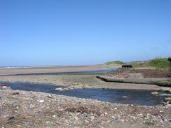
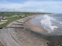
Sam dropped me off at the car park in Gosforth quite early on, and I walked the short distance down to Seascale. Sam met me at the station car park in the village, to see if I was okay and wanted to continue. My ankle was not giving me much trouble, and so I decide to continue on. The path past the Sellafield complex was quite interesting, with the buildings towering to my right. There were several locomotives in the yard in the complex, and I could clearly see the wagons on which nuclear materials are carried. After this I had to divert down onto the beach, and whilst the initial stretch was along firm sand, this eventually ended and I was forced to walk along a stretch of cobbles and shingle. This was quite hard going, and I took it easy, as I was concerned about putting more strain on my injured ankle. At one stage I came to another stretch of sand, but as soon as I stepped onto it I sank up to the middle of my calf, and my walking poles went a couple of feet straight down. I carefully pulled myself out of the sand, which had a thick layer of mud beneath it and I went back to walking on the cobbles - I was not going to risk going into some bottomless pit!
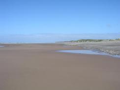
Eventually I reached a nice area of firm sand just before I reached St Bees. This was a joy to walk on after the cobbles, and I walked along to meet Sam at the car park by the beach. She had not arrived yet, so is at down on a bench in the sunshine and made her a daisy chain, which I gave to her when she arrived. I ate my sandwiches in Mervan, and then my parents phoned and said that they would join us. This meant that I ended up having a very long lunch break, but it was great to see them again. We had a nice chatter before I set off to walk along to Whitehaven. St Bees is also the start (or end) of the coast-to-coast walk, and it was with some amusement that I realised that I had walked from Robin Hood's Bay (the endpoint on the east coast) to St Bees by the longest possible route!
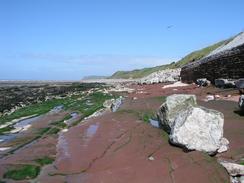
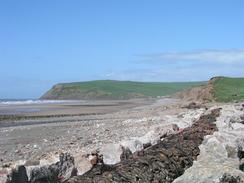
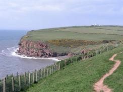
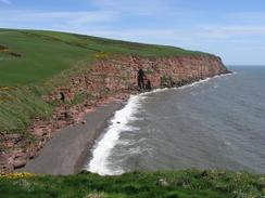
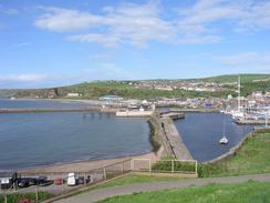
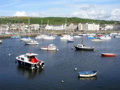
This stretch of walk involved going up and around St Bees Head, which was the best stretch of coastline that I have seen for some time. The cliffs are made of a lovely red sandstone that seemed to glow in the warm afternoon sunshine. The walk was absolutely superb and very enjoyable, and I took my time so that I could enjoy the views, which included the Isle of Man, which I could see quite clearly in the distance. As I was descending down into Whitehaven I met Sam, mu mum and my dad, who had walked up to meet me. We took a slow amble downhill chatting as we went until we got into the centre of Whitehaven. The town is quite lovely, with the harbour area being particularly pretty and well cared for. In particular the seats around the harbour were very nice and substantial, with little facts about the town engraved into them.
Mum and dad invited us to go for a meal, so we found a charming little cafe on the harbour front called Zest, which we went into for a lovely meal. Much later (and slightly more lubricated) we staggered out, and Sam and I walked on for another couple of miles to the village of Parton, where she had parked Mervan. We chatted outrageously as we walked along the old tramway to the village, and a local man who walked past us looked quite amused by out antics.
Considering how much my ankle was hurting me yesterday I am quite pleased that I managed to do a long day's walk, albeit at a relatively slow speed and with several long stops. Tomorrow I should get past Maryport, from when I will have to walk eastwards to Carlisle and the Scottish border.
 |
Directions
This walk starts off at a car park in the village of Gosforth. Leave the car park and turn right to head past the pubs in the village to reach the A595(T) road. Continue straight on and head southwestwards along the B5344 road for nearly three miles, passing Cross Lanes and entering the village of Seascale. Pass the station and follow the road as it heads under the railway line and reaches a car park.
From here the path follows the Cumbrian Coastal Way for the rest of the day. Continue through the car park and follow a path that runs northwestwards, with the railway line to the right, until a rail bridge over the River Calder is reached. Head under the railway line to cross over onto the landward side, and then climb up to take a footbridge over the river, after which the path continues on, crossing a level crossing that leads into Sellafield's private sidings before it eventually reaches Sellafield Station. Head straight on past the station before taking a footpath that heads uphill and follows the edge of a little hill northwestwards for about a kilometre until it descends to meet the southern bank of another little river. Climb up to the rail bridge, where a path leads over the bridge, and once on the other side descend back down to the floodplain and pass under an archway onto the seaward side of the railway line.
Follow a path that heads northwestwards through some low sand dunes, or go onto the beach and follow that instead. It starts off sandy, but later becomes stony with some shingle and cobbles, which made walking tricky in places. The beach passes Braystones and Nethertown, before eventually a car park is reached to the south of St Bees. From here another sandy stretch of beach continued on for a kilometre, until a car park at St Bees is reached. Enter the car park and continue past the lifeboat station to a little footbridge over a stream, from where a good footpath head up some steps that led up onto the top of South Head.
Follow the footpath around South Head and down into a little dry valley, out of which it climbs up to go around North Head, passing the lighthouse. The path then runs along the top of the cliffs and is clearly defined as far as Whitehaven, where it leads down into the town to pass the Beacon and the Harbour. Walk around the harbour and make your way towards the Tesco store. Climb up a road past the Tesco's and then take a cycle path that runs along the trackbed of an old tramway past Redness Point to reach the station in Parton, where this walk ends.
For more details of the Cumbria Coastal Way, see the excellent little book, The Cumbria Coastal Way: A Walker's Guide", by Ian and Krysia Brodie, ISBN 187355110X. This book is a lovely and detailed description of the walk, and unfortunately I did not manage to get a copy until after I fnished the walk, for it would have been quite handy.
Distances
| From | To | Distance (m) | Ascent (ft) | Descent (ft) |
|---|---|---|---|---|
| Gosforth | Seascale | 2.8 | 79 | 230 |
| Seascale | St Bees | 8.6 | 304 | 300 |
| St Bees | Whitehaven | 7.0 | 800 | 805 |
| Whitehaven | Parton | 1.9 | 285 | 276 |
This makes a total distance of 20.3 miles, with 1468 feet of ascent and 1611 feet of descent.
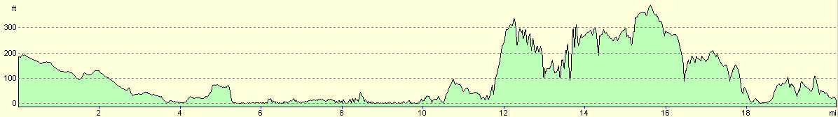
For more information on profiles, ascents and descents, see this page
Accommodation
We parked in a car park by the station in the village of Parton, which was quiet enough. There was a pub, The Station, directly opposite us, but we did not go in to see what it was like.
Disclaimer
Please note that I take no responsibility for anything that may happen when following these directions. If you intend to follow this route, then please use the relevant maps and check the route out before you go out. As always when walking, use common sense and you should be fine.
If you find any information on any of these routes that is inaccurate, or you wish to add anything, then please email me.
All images on this site are © of the author. Any reproduction, retransmissions, or republication of all or part of any document found on this site is expressly prohibited, unless the author has explicitly granted its prior written consent to so reproduce, retransmit, or republish the material. All other rights reserved.
Although this site includes links providing convenient direct access to other Internet sites, I do not endorse, approve, certify or make warranties or representations as to the accuracy of the information on these sites.
And finally, enjoy your walking!
This walk was mentioned in the following routes:
| My walk around the coastline of Britain |
Nearby walks
| # | Title | Walk length (miles) |
|---|---|---|
| 433 | Haverigg to Ravenglass | 19.8 |
| 434 | Ravenglass to Wasdale Head, via Seascale | 17.7 |
| 435 | Wasdale Head to Gosforth via Mickleden and Scafell Pike | 13.4 |
|
|

|