Walk #192: Lewiston to Beauly
 |
 |
|
General Data
| Date Walked | 27/04/2002 |
| County | Highlands |
| Start Location | Lewiston |
| End Location | Beauly |
| Start time | 09.15 |
| End time | 15.55 |
| Distance | 14.7 miles |
| Description | This was a long road walk that included some lovely views over moorland. This walk shows that road walking is not necessarily all bad. |
| Pack | Full pack with three days food. |
| Condition | I feel okay after this walk. I had no trouble with my knee and my back and shoulders are fine. My left ankle is aching after the walk which is slightly worrying, but I will see what it is like after tomorrow's walk. |
| Weather | I woke at 6 this morning and went into the hostel's kitchen, to be greeted with a few minutes worth of snowfall. This soon became sleet, and the temperature was too warm for the snow to settle. This was a bad omen for the day, but fortunately it was not an omen that came to pass. The weather today was a combination of sunshine and cloud, with a fierce wind that chilled me if I was stationery in an exposed location. However it could have been much worse, so I have no complaints. |
| OS map | Landranger number 26 (Inverness & Loch Ness) |
 |
 |
|
Map of the walk
Maps courtesy of Google Maps. Route for indicative purposes only, and may have been plotted after the walk. Please let me have comments on what you think of this new format. For a detailed table of timings for this walk, please see the table file.
Notes
The sight of a small snow flurry early in the morning meant that I was not looking forward to this walk. Fortunately the weather during today was okay, with sunny periods and a strong wind. The one good thing about the overnight snow was that the very high hills in the distance had white caps of snow, which made them look all he prettier.
I found it very hard to make myself leave the hostel this morning as I had very much enjoyed myself there the previous evening and would not have minded staying another night. However I felt that I could not afford to take a day off when I was only seven days into a three week trip, so I continued on. In Drumnodrochit I stopped off at the shop and bought a few provisions, including some pens as I could not locate one first thing this morning. It was then with a heavy heart that I set out away from the village.
The climb out of Drumnadrochit along the A833 road looked worse on the map than it really was; although it was steep in places the climb was easily achievable and the total ascent was only about 200 metres, much less than yesterday's. Although I had to stop one or twice on the very steep sections to catch my breath, I made it to the top in good time.
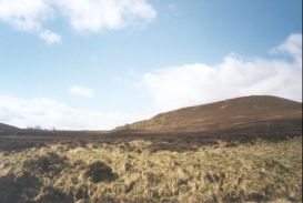
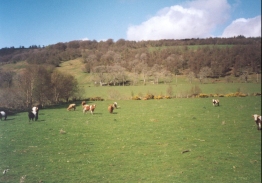
One of the features of this walk is the moorland at the top of the A833 around the summit of Meall Gorm, which was very nice. It reminded me very much of certain moorland in the Dark Peak of Derbyshire, and it certainly made the climb worthwhile. There was a strange contrast however, for as soon as I had descended down into Glen Convinth the area was surrounded by pasture. It was like travelling from one landscape to another in a little over a mile.
The only bad thing about today was that the entire distance was along roads, which were hard on my feet and my ankle. Fortunately for the majority of the time the roads were quiet, with a car passing every few minutes, and I therefore felt fairly safe.
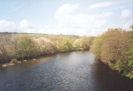
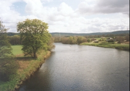
Beauly must have been much more important in past times, as it would have been the first bridge over the River Beauly north of Inverness (the Kessock Bridge now carries the A9(T) over the river to the north of the city. As such the roads are now quieter than they otherwise should be and Beauly itself seems quiet.
I stopped for an extended lunch at the Brockies Lodge Hotel near Kiltarlity on the A833. I had a lovely meal which was washed down with a couple of pints whilst I chatted to some of the customers in the pub. Consequently I spent far longer over lunch than I had intended, but it did not matter as it did not rain later in the journey and at least it gave a chance for my feet to recover from the punishment that they were getting from the tarmac.
Beauly is a lovely little town, and indeed that is where it's name comes from - the French word 'beauliey',which means beautiful place. Once I dropped my pack off at the B&B I had a quick look around the town, and spent some time looking at the ruins of the Valliscaulian Priory, built in 1230. The ruins are quite impressive, and the stone has a lovely colour - indeed many of the local buildings use the same stone, which makes the whole town look nice in my opinion. All in all Beauly is a lovely little town, and it made for a fine place to stop for the night.
After a quick lie down in the B&B I went into the Beauly Centre beside the Priory to ask about accommodation in either Contin or Garve, although the gentleman there could not help me with that request (although he had an accommodation booklet for the area which did help), I spent a lovely forty minutes looking around the centre, which includes a 1940's shop, based on goods from a shop in Aberlour which was locked up during the second world war and nor reopened for fifty years, leaving all the goods untouched. There were also a set of weaving looms in working order, and the gentleman told me that he wants to get a sheep in, shear it and produce a garment all on the premises to show people how garments get created. The centre was a very worthwhile distraction, and I enjoyed it immensely.
When I got to Beauly I felt that with a little rest I could have continued on to Muir of Ord, another three miles down the road. However the only place that I knew of for accommodation tomorrow night was at Contin, seven miles further on. However I have since discovered that there is accommodation available in Garve, another six miles further on. This means that I either have ten miles to walk to get to Contin, or over sixteen to get to Garve.�I will probably wait to see how I feel when I get to Contin before making any decisions.
Directions
This walk starts off at the bridge that carries the A82(T) road over the River Coiltie in Lewiston, just to the Southeast of Drumnadrochit. Head west over the bridge and follow the A82(T) as it starts to turn to the north to enter Drumnadrochit. Pass the tourist information office and carry on up a slight hill to a T-junction with the A831 road. There is a pedestrian pavement for the whole distance.
Turn left and follow the A831 west past a Nessie exhibition centre. Follow this road for about two kilometres past the village of Milton until the junction with the A833 road is reached on the right.
Turn right and start the steep climb north-eastwards up the A833. After about a mile the climb becomes less steep as it passes Bainagrantach. The road now traverses a pleasant section of moorland, which is dominated by the 415-metre hill of Meall Gorm on the left. The A833 is a fairly quiet road (or at least it is at the time of year that I walked it) so it is a relatively good road walk.
Eventually the road passes to the right of a mast planted on a nearby hillside. Here the descent starts in earnest and the pleasant Glen Convith is entered. The road is less twisty as it descends, and eventually takes an a northerly heading until a hotel is reached at the junction with the road from Kiltarlity.
The road then gets slightly busier as it climbs to the Northeast to a junction with the A831 road. Turn left along the A831 and follow it north-westwards for a couple of kilometres past the B9164 junction to Lovat Bridge; be careful crossing the bridge as the road is narrow and there is no pedestrian pavement.
Immediately on the western side of Lovat Bridge there is a road junction. Turn right and follow the A862 north-eastwards for a kilometre until a bridge over a railway line beside the newly-opened Beauly Station. The village of Beauly is immediately on the other side of the railway bridge.
Distances
| From | To | Distance (m) | Ascent (ft) | Descent (ft) |
|---|---|---|---|---|
| Lewiston | A831 / A833 Junction | 2.5 | 207 | 79 |
| A831 / A833 Junction | Brockies Lodge Hotel | 8.4 | 988 | 1122 |
| Brockies Lodge Hotel | Beauly | 3.8 | 148 | 243 |
This makes a total distance of 14.7 miles, with 1343 feet of ascent and 1444 feet of descent.
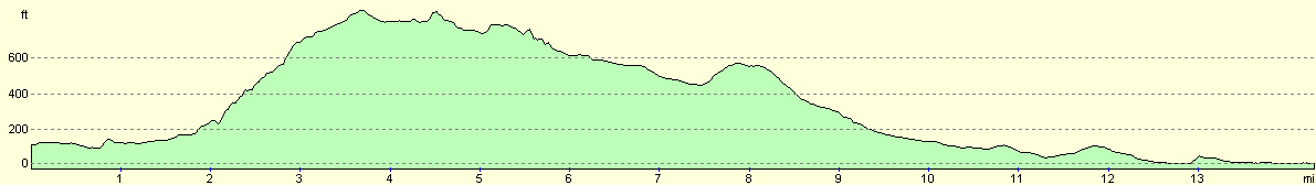
For more information on profiles, ascents and descents, see this page
Accommodation
I stayed at the Lyndale Guest House, on Station Road in Beauly, Inverness, IV4 7EH. Telephone 01463 783 672. This was a nice B&B which cost 25 pounds for a one night stay.
Disclaimer
Please note that I take no responsibility for anything that may happen when following these directions. If you intend to follow this route, then please use the relevant maps and check the route out before you go out. As always when walking, use common sense and you should be fine.
If you find any information on any of these routes that is inaccurate, or you wish to add anything, then please email me.
All images on this site are © of the author. Any reproduction, retransmissions, or republication of all or part of any document found on this site is expressly prohibited, unless the author has explicitly granted its prior written consent to so reproduce, retransmit, or republish the material. All other rights reserved.
Although this site includes links providing convenient direct access to other Internet sites, I do not endorse, approve, certify or make warranties or representations as to the accuracy of the information on these sites.
And finally, enjoy your walking!
This walk was mentioned in the following routes:
| My sectional Land's End to John O'Groats walk |
Nearby walks
| # | Title | Walk length (miles) |
|---|---|---|
| 191 | Alltsigh to Lewiston | 9.5 |
| 193 | Beauly to Garve | 16.4 |
| 540 | Dingwall to Cromarty | 24.0 |
|
|

|