Walk #178: Broadstone to Church Stretton
 |
 |
|
General Data
| Date Walked | 20/01/2002 |
| County | Shropshire |
| Start Location | Broadstone |
| End Location | Church Stretton Station |
| Start time | 09.17 |
| End time | 12.35 |
| Distance | 8.1 miles |
| Description | This walk was a little boring after yesterday, but the high point was literally the crossing of Wenlock Edge. The going was very muddy and the sometimes damp weather did not help me enjoy it. I was also in a hurry to finish as I had a train to catch, so my route was not as nice as it could have been if I had more time. |
| Pack | I used my Craghoppers 70-litre rucksack on this walk, and although I did not have a tent or Trangia with me I had my sleeping bag and spare clothes, making it a medium-weight pack. |
| Condition | I was fairly fatigued after this walk, which is slightly surprising as today's walk was not too strenuous. Nothing in particular aches, but I think that the muddy ground made the going harder than it should have been. After an hour's rest by the time the train came I was very much recovered and could easily have continued on for a few more miles. I have no new blisters and my feet, back, shoulders and ankles all feel fine. |
| Weather | The weather forecast for today was for high winds and some heavy rain, so it was with a little trepidation that I set out. Fortunately although it rained at times I did not rain heavily until I was in the shelter at the station at the end of the walk, and the wind was only bad when I was exposed on Wenlock Edge. It was very mild for the time of year which meant that my choice of wearing many layers did not work too well. |
| OS map | Landranger number 138 (Kidderminster & Wyre Forest) |
 |
 |
|
Map of the walk
Maps courtesy of Google Maps. Route for indicative purposes only, and may have been plotted after the walk. Please let me have comments on what you think of this new format. For a detailed table of timings for this walk, please see the table file.
Notes
Today got off to a lovely start in the form of an absolutely superb breakfast in the B&B, firmly reinforcing the impression that I got yesterday about this being a first rate establishment. The only slight cloud on the horizon was the weather forecast, which was promising rain. A quick glance out of the window showed me that it was not raining at the time but that the roads were wet with rain, so I hoped that the rain would not restart.
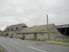
The previous day I had seen a sign in the forest on the climb up to the summit of Brown Clee Hill saying that a car rally was going to come through the next day. When I got to the climb from Hungerford up to the top of Wenlock Edge today I saw a series of signs denoting a checkpoint at the junction of the track with the road. A local farmer who was carrying a bail of hay on a pitchfork told me that the rally was coming through later. Later on I saw a whole series of cars, some classic (including an MG T series), and others more modern, driving along the road towards Tickerton.
The lane leading up onto Wenlock Edge from the road at Hungerford was basically a sunken lane. At first I thought that it was paved, but a closer inspection showed the base of the track to be on a rocky surface that was inclined at the same angle as the hill, so large flat surfaces were visible. The rock had a grey colour that looked fairly attractive in the wet, but I was not able to identify it. Later research has shown that the whole of Wenlock Edge was once a large coral reef, so perhaps the rocks that I saw were something to do with that.
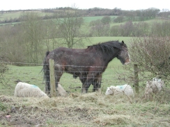
The descent down from Wenlock Edge to Eaton was quite steep and very muddy, which made the going quite hard. This stretch of the walk was through woodland, and it did not look very attractive in the damp conditions - the mud certainly did not help ease this impression. Near the bottom of the hill I could see some horses coming up the narrow track, so I paused and pulled in onto another path so that they could pass. It turned out to be two riders on three horses, the riderless horse being roped up between the other two. The lead horse took a slight fright to my presence, and so the rider had to pat it to make it calm down.
Shortly past Eaton church on the way to Tickerton a car pulled up beside me and a lady opened her window. It turns out that she had lost her dog, and she was asking me about whether I had seen it. I had to reply in the negative, and she looked fairly distraught.
I got to Church Stretton at about the time I was expecting, and I had a wait of about an hour for the first train to Shrewsbury. As soon as I got into the station it started to rain fairly hard, so I decided to stay in the shelter instead of finding a pub for some food and drink. The train arrived on time and I got to Shrewsbury, but hen had a long wait for the next train to Birmingham. It turned out that this service was being replaced by a bus which got into Birmingham New Street station five minutes before a train that set off an hour later from Shrewsbury, so I opted to wait the extra hour in the relative comfort of the buffet at Shrewsbury Station. When I got to New Street I found out that the next train to Bromsgrove (where I was going to get my life back to Cambridge) was not until 18.00. Fortunately a friend came to pick me up, which was very nice. Even with this lift I had been in 'travelling mode' (either travelling or getting ready to travel) for over 5 and a half hours today. When in New Street Station I used the opportunity to change out of my muddy clothes and into some clean ones so that I would be more respectable for the rest of the journey home.
This walk gives me two options as to the way forward; the first is to follow the railway line south (via the Long Mynd) to Craven Arms and then points west; the other is to head directly west (again via the Long Mynd) to Bishop's Castle and then west. Obviously following the railway line will make transport easier, but the most scenic route may well be the latter one.
Directions
This walk starts off from Rowe Cottage in Rowe Lane, Shropshire, where I spent the previous night. Turn left out of the cottage and follow Rowe Lane southwestwards. Take the first road to the right which leads northwestwards to meet the B4368 road.
Turn left and carefully walk along the B4368 for about seven hundred metres until the road enters a little cutting in Hungerford. Opposite a farm building a bridleway leads up the hill to the northeast along a sunken lane. Take this lane and follow it as it climbs for about a mile up to the top of Wenlock Edge at Topley.
At Topley the bridleway ends at a road. Follow this road as it heads northwards and then northwestwards to the northern side of Wenlock Edge. Just before the road starts to descend down Roman Bank another road appears from the left. Turn left down this road and then almost immediately right down a minor road that skirts the edge of the hillside as it heads to the southwest.
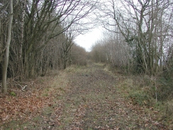
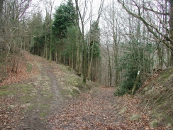
The track stops being surfaced and becomes a green lane as it skirts the upper edge of some forested land. When the track ends at a gate continue across straight on across a field, again skirting the upper edge of the woodland. On the other side of the field the bridleway enters the woodland and then starts to descend steeply down the hill, following the Jack Mytton Way.
The bridleway emerges onto a road at the bottom of the hill beside Eaton Church. Take the road as it heads northwestwards, passing under the abutments of an old railway bridge, and emerges after about a mile in the little village of Ticklerton.
When the road ends at a T-junction in Ticklerton turn right for a short distance before taking the first road off to the left. This road heads northwestwards though Soudley before ending at the B4371 road at Hope Bowdler.
Turn left along the B4371 and follow it as it heads northwestwards for a little over a kilometre. When two roads come in from the left at one junction take the second one, Hazler Road, as it heads to the west downhill through Hazler. This road ends at the bottom of the hill at the B4371 once more. Turn left along the B4371 for a very short distance until the A49(T) Crossways is reached. Turn left along this road and take the first road to the right, which leads down to Church Stretton Station. Trains to Shrewsbury and the north leave from Platform 1, which is over the footbridge.
Distances
| From | To | Distance (m) | Ascent (ft) | Descent (ft) |
|---|---|---|---|---|
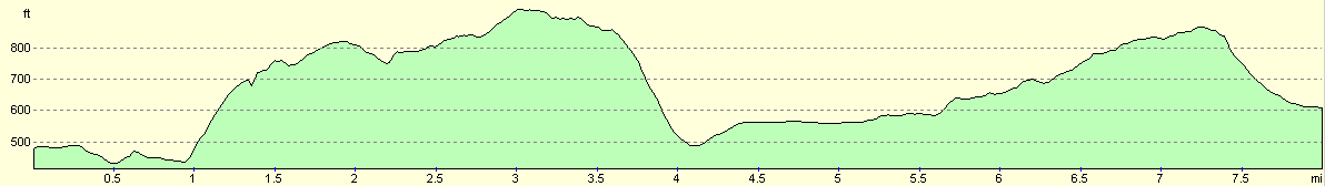
| Broadstone | Eaton | 4.1 | 689 | 663 |
| Eaton | Church Stretton | 4.0 | 449 | 341 |
This makes a total distance of 8.1 miles, with 1138 feet of ascent and 1004 feet of descent.
For more information on profiles, ascents and descents, see this page
Transport
There are train services running from Church Stretton to Shrewsbury in the north and Craven Arms in the south. From Shrewsbury regular train services can be got to many destinations, including Manchester and Birmingham. Unfortunately the train services from Church Stretton are fairly irregular on Sundays, and do not start until just before midday.
Disclaimer
Please note that I take no responsibility for anything that may happen when following these directions. If you intend to follow this route, then please use the relevant maps and check the route out before you go out. As always when walking, use common sense and you should be fine.
If you find any information on any of these routes that is inaccurate, or you wish to add anything, then please email me.
All images on this site are © of the author. Any reproduction, retransmissions, or republication of all or part of any document found on this site is expressly prohibited, unless the author has explicitly granted its prior written consent to so reproduce, retransmit, or republish the material. All other rights reserved.
Although this site includes links providing convenient direct access to other Internet sites, I do not endorse, approve, certify or make warranties or representations as to the accuracy of the information on these sites.
And finally, enjoy your walking!
Nearby walks
| # | Title | Walk length (miles) |
|---|---|---|
| 177 | Bridgnorth to Broadstone | 15.5 |
| 182 | Knighton to Craven Arms | 15.3 |
|
|

|