Walk #151: Bridge of Orchy to Kings House Hotel
 |
 |
|
General Data
| Date Walked | 22/08/2001 |
| County | Strathclyde, Highlands |
| Start Location | Bridge of Orchy Hotel |
| End Location | Kingshouse Hotel |
| Start time | 09.15 |
| End time | 14.25 |
| Distance | 12.1 miles |
| Description | This was a pleasant walk, following the West Highland Way as it heads northwards across the Black Mount to Glen Coe. |
| Pack | Today I carried full Pennine-Way spec kit. |
| Condition | Fair to middling. My legs and feet feel fine, although I have some raw bits on the top of both of my big toes - something that I have never experienced before. The worst thing, however, is my lower back, which is very red and sore attimes when my pack was rubbing against it. This is far more annoying than any pain that I was getting from my feet, and for short periods I was walking with the hip strap of my rucksack undone and was lifting the bottom of my rucksack away from my back. |
| Weather | The weater today was absolutely glorious. The sky started off slightly cloudy, but as the day progressed there were longer and longer periods of sunshine. A little wind halped me keep cool, and fortunately there was never any sign of any rain. In short it was superb weather for walking in the hills. |
| OS map | Outdoor Leisure number 38 (Ben Nevis & Glen Coe) or Landranger number 50 (Glen Orchy & Loch Etive) and Landranger number 41 (Ben Nevis, Fort William & Glen Coe) |
 |
Map of the walk
Maps courtesy of Google Maps. Route for indicative purposes only, and may have been plotted after the walk. Please let me have comments on what you think of this new format. For a detailed table of timings for this walk, please see the table file.
Notes
This walk was a very straight-forward stroll along some good estate tracks and was very entertaining. This section of the West Highland Way should really be called the West Highland Motorway, due to the width of the track and the sheer number of people walking along it - it is a slight culture shock to see so many people walking after not having seen any walkers for the past few days. There are many different nationalities walking the West Highland Way - Dutch, Germans, New Zealanders and Candians are the main ones, with a few British people thrown in to make up the numbers.
I managed to power my way up the first part of the walk because the going was so good, and my first stop for a rest was at the delightful Ba bridge more than halfway into the day's walk. I managed to scramble over the rocks beside the falls to take some photogrpahs of it close up; it was quite a sensation to get that close to the rushing water.
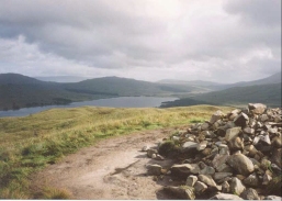
After the stop at Ba Bridge I started walking with three ladies from London who were doing the West Highland Way. Conincedentally they worked for Queen Mary and Westfield college, my old university in London, although on another campus. We walked together for about an hour or so until we stopped at a pace that had some glorious views over Rannoch Moor, and then I continued on my own and reached the Blackhouse Inn in good time. I then proceeded to have three or four pints before going over the bridge to the area of the land behind the hotel to put up my tent. Putting up a tent when you have had a few drinks is always an interesting experience, and this was no exception. I thought that I had put it up well, but when I came back later in the evening the fabric was not as taut as I normally get it, and I realised that I had erected it slightly askew. After putting the tent up I went back into the hotel to have a delicious meal of venison and to have yet more alocohol. I had the company of the three ladies from London all evening, and we chatted about various London-related things. I then retired to my sleeping bag, weary and very drunk.
I have a decision to make first thing in the morning - whether to continue to Fort William along the West Highland Way or to go along the route I had been plannig to take, which would take me north past the dam of Blackwater Reservoir. The former has the advantage of being an easier route and of having the camerarderie of the trail, but has the disadvantage of not being what I set out to do. The latter has the advanatge of being the route that I wanted to do, but it is much harder and much of it is over ground with no tracks. Considering the poor state of my back I think that I may end up taking the easier route.
Buchaille Etive Mor is a beautiful mountain when viewed from Glen Coe, and is very spectactular guardian to this ancient pass through the mountains. It is views like this that make me want to climb mountains - it is a shame that I have not done any for such a long time - the last Munro that I climbed was eleven years ago, in 1990.
After I had set up my tent and unpacked my rucsack I left my tent and started chatting to a couple of hardened walkers. I happened to mention that I was intending to walk the Cape Wrath Trail next year, and they replied that they had attempted to do it before and had ony got as far as Strathcarron. Apparently they had been trying to do the entire walk in two weeks, which is an average of about fouteen miles a day, but had found that they could only manage between seven and eight due to the terrible terrain. Attacks every morning by midges had also worn them down. This has made me even more concerned about doing this walk, particularly as I am planning to do it on my own. One of them said that if I were to follow the route described in Patterson's book the Cape Wrath Trail and I were to injure myself then I would be dead, as the walk went through what he described as some immensely remote areas. This is of course a highly pleasant thought.
Directions
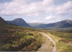
This walk starts off at the Bridge of Orchy Hotel. From the front of the hotel turn left along the A82(t) for a short distance and then take the road to the first left, which leads past the side of the hotel and descends to the bridge over the River Orchy. Cross over the bridge and, when the road turns shrply to the right, take a footpath that leads off straight ahead. This path is waymearked as the West Highland Way, and it will be followed all the way to Glen Coe.
The path rises up the hillside to the west of the River Orchy in a general northwesterly direction. After about a kilimotre it breaks out of the forest, and a slight incline leads up to the summit of Mam Carraigh, where a short track laeds up to a cairn from where some lovely views over the Black Mount and Loch Tulla are available. The path then descends down to a road at the Inveroran Hotel.
Turn left down the road and follow it past the Hotel. Shortly after this a bridge caries the road over the Allt Tolaghan, which drains into Loch Tulla. The road then turns northwards and leads to Victoria Bridge (over the Abhainn Shira) and Forest Lodge.
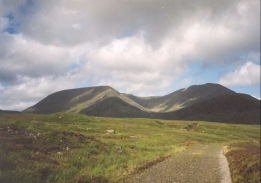
At Forest Lodge leave the road and head over a stile to join the Old Glencoe Road as it ascends northeastwards. The going is very easy, with a wide unsurfaced road making for fast going. The track starts skirting to the left of some woodland, the end of which signifies the end of the rise. The track then continues in a rough northerly direction, crossing over Allt Doire Mhic Laimh and then to the right of a small wodded area. The track then starts a sllight descent down past to the left of another wooded area and Lochan Mhic Pheadair Ruaidhe before finall reaching the River Ba. Along this section some lovely views are available, with Coireach a Ba visible to the west and Rannock Moor to the east.
The River Ba is crossed by mans of Ba Bridge, and after this the track starts to rise slowly as it heads north. It reaches a high point of about 445 metrs near NN 282 511, and then starts to descend slowly as it skirts the eastern flank of Gualann Laith Ghiubhais. As it does so it chnages from a northerly to a northwesterly direction, and the track becomes rougher.
Eventually a tarmacced road is reached at Blackrock Cottage. Turn right to join this road and follow it for about six hndred metres until you meet the A82(T) road. Cross over the road and follow a track to the northwest for a kilometre to reach the Kings House Hotel.
For more details on this walk, look at the West Highland Way website.
Distances
| From | To | Distance (m) | Ascent (ft) | Descent (ft) |
|---|---|---|---|---|
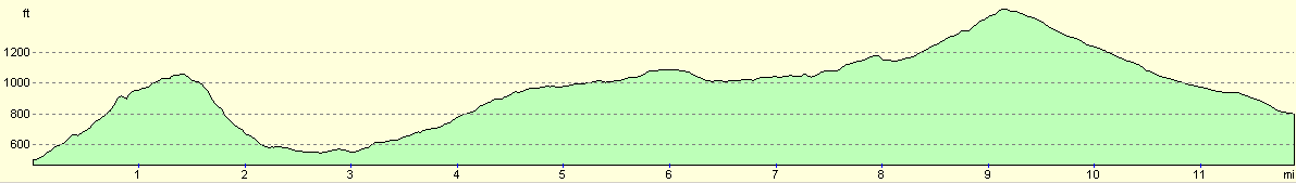
| Bridge of Orchy | Inveroran Hotel | 2.4 | 597 | 509 |
| Inveroran Hotel | Ba Bridge | 5.1 | 666 | 210 |
| Ba Bridge | Kingshouse Hotel | 4.6 | 489 | 732 |
This makes a total distance of 12.1 miles, with 1752 feet of ascent and 1451 feet of descent.
For more information on profiles, ascents and descents, see this page
Accommodation
I stayed in a tent across the river from the Kings House Hotel. The hotel also has rooms available, but it fills up rapidly in summer with walkers so booking in advance is advised. If you camp then breakfasts in the morning can be bought for seven pounds, and this proves to be a good way to escape the curse of the morning midges. The Hotel also sells very nice evening meals and some excellent beer.
Disclaimer
Please note that I take no responsibility for anything that may happen when following these directions. If you intend to follow this route, then please use the relevant maps and check the route out before you go out. As always when walking, use common sense and you should be fine.
If you find any information on any of these routes that is inaccurate, or you wish to add anything, then please email me.
All images on this site are © of the author. Any reproduction, retransmissions, or republication of all or part of any document found on this site is expressly prohibited, unless the author has explicitly granted its prior written consent to so reproduce, retransmit, or republish the material. All other rights reserved.
Although this site includes links providing convenient direct access to other Internet sites, I do not endorse, approve, certify or make warranties or representations as to the accuracy of the information on these sites.
And finally, enjoy your walking!
This walk was mentioned in the following routes:
| My sectional Land's End to John O'Groats walk |
Nearby walks
| # | Title | Walk length (miles) |
|---|---|---|
| 150 | Gleann Meran to Bridge of Orchy Hotel | 11.1 |
| 152 | Kings House Hotel to Kinlochleven | 8.7 |
| 907 | West Highland Way: Inversnaid to Tyndrum | 19.1 |
|
|

|