Walk #100: A circular walk including Inkpen, Walbury Hill and Pilot Hill
 |
 |
|
General Data
| Date Walked | 15/07/2000 |
| County | Berkshire, Hampshire |
| Start Location | Walbury Hill car park |
| End Location | Walbury Hill car park |
| Start time | 10.40 |
| End time | 14.44 |
| Distance | 10.4 miles |
| Description | This was a lovely circular walk taking in the highest points of Hampshire and Berkshire. It also linked up with the route of my Land's End to John O'Groats walk. |
| Pack | Full Pennine Way kit. |
| Condition | I feel reasonable after this walk. I am still recovering from a bout of tonsillitis, so was quite weakened. Despite this the walk went quite well, and had no injuries of any sort at the end. |
| Weather | Today's weather was about 50:50 sunshine and cloud, without a hint of any rain. It was quite warm on the lowland plains, but on the Wayfarers Way the wind made it quite chilly, particularly in exposed locations. |
| OS map | Landranger number 174 (Newbury & Wantage, Hungerford & Didcot) |
 |
Map of the walk
Maps courtesy of Google Maps. Route for indicative purposes only, and may have been plotted after the walk. Please let me have comments on what you think of this new format. For a detailed table of timings for this walk, please see the table file.
Notes
A very nice day that saw me visit the highest points in both Berkshire and Hampshire, and thus get my target of visiting all the highest points in England under progress once again. It also allowed me to connect this walk to my Land's End to John O'Groats walk.
Because I wanted to connect up the walk with my Land's End to John O'Groats walk, I extended what would otherwise have been a rather simple walk and dropped down to the valley floor to walk through Inkpen Common to the drive of Holt Lodge, where I spent one night on my Land's End to John O'Groats walk. This meant of course that I had to climb back up to the ridge, which was fun but slightly tiring.
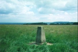
The trig point on Pilot Hill (Hampshire's highest point) is not visible from the Wayfarers Way, and is in a field out of view just over the brow of the hill. I opened the gate and went into the field to find the trig point, but as there was no footpath to it this was technically trespassing. It is nice to be able to scratch another counties highest point off my list, however.
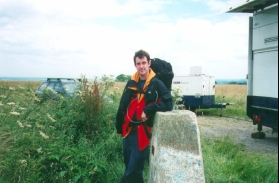
On Walbury Hill I reached the trig point to find possibly the busiest trig point that I have ever seen - a BBC van was parked beside it, acting as a relay station for the broadcasts from the Newbury races. There was also a tent and a very tall jury-rigged antenna, both of which were owned by two gentlemen who were taking part in a short-wave radio competition. Apparently there are people all over the UK broadcasting their location and a code. Every signal that the competitors pick up is logged, and the ones who pick up the most signals over the most area (according to grid squares) wins. Obviously Walbury Hill (being the highest point for quite an area around it) is ideal for broadcasting and receiving. Whilst I was there they were getting signals loud and clear from Scotland, and were hoping to be able to receive signals from Ireland later on in the day.
All in all this was a lovely walk, although it involved more road walking than I would ideally have liked. The main thing is that despite still suffering from the after effects of the tonsillitis I have had for over two weeks, I have recovered enough to do this short walk. Unfortunately I did not feel one hundred percent through the walk, but that was too be expected. The main thing is that I successfully completed it.
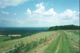
Most of the views from the ridge between the two trig points are marvellous, with expansive views being available to the north over towards the Ridgeway. The Wayfarers Walk follows the ridge for a much greater distance than the little section that I did today, so I may come back sometime and do some more of it, including the so-called 'Watership Down' section a little way to the east towards Newbury.
Once I had finished the walk and got back to my car at the Walbury Hill car park, I decided to drop off my pack and go for a short walk up to Combe Gibbet on Inkpen Hill and watch the hang-gliders throw themselves off. Combe Gibbet is the location where a man and his mistress were hung for murdering his wife and two children. Ever since the Gibbet has remained in place, although it has apparently been rebuilt many times by locals after lightning strikes, vandalism and the general ravages of nature.
The scenery in this area is lovely, and whilst it is not classic hill walking country it does have some relatively high and steep hills in it. I feel that I will be back to this area to do some more walks soon. In particular I would like to walk from Inkpen down to Newbury and then up to Uffington and the Vale of the White Horse, and also walk parts of the Wayfarers Way.
Directions
Start from the car park to the west of Walbury Hill fort at SU 371 620. Head along the road to the southwest down quite a steep hill. After just over a kilometre take the first right that heads to the northeast along a road that bends round to Upper Green. Take the first right out of Upper Green that takes you past a public house (the only refreshment opportunity on the walk) and on past the nature reserve at Inkpen Great Common on the right.
When the end of the road is reached at a T-junction turn right and walk past the entrance drive to Holt Lodge B&B (I stayed here at the last night of my walk from Bath to Newbury). Continue along the road until you come to a road heading off to the left. Do not take this road, but take the next right that takes you along a very pleasant wooded road. At the end of this road turn left to head to the southeast past West Woodhay Church.
Just past West Woodhay church take a road to the right that heads to the southeast, passing Woodcut Copse before crossing the Berkshire / Hampshire border and into East Woodhay. At the end of the road just past East Woodhay Church take the right heading to the south. After about a kilometre the road starts to ascend steeply, and at the start of the ascent, just after a right-hand bend, a footpath heads through a wooded area steeply to the right. Take this footpath up through the wood and then on steeply up a pasture to the west. At the top of the hill join the Wayfarers Way (At this point the Wayfarers Way follows a track between hedgerows). Turn right and follow the track as it heads eastwards.
Shortly after joining the track you start passing a wooded area. Before this there is a gate to the left that allows access to the field to the left, where the trig point for Pilot Hill, the highest point in Hampshire at 286 metres can be reached.
Continue along the track to the northwest. The track descends for a while before starting to climb again up to Walbury Hill, the site of a prehistoric fort. At the top of the hill a track leads off for a short distance to the left, leading to the top of the fort and a trig point at the highest point in Berkshire (297 metres).
From the top of the fort the track leads back down to the car park. It is worthwhile taking a short walk along the track to the west that leads up to Combe Gibbet, a place where a couple were hung for murder many years ago and from where some wonderful views are available to the north.
Transport
There are two car parks available for this walk, one to the east of Walbury Hill (which is the one that I used), and one to the west. Both are on the route, and therefore are equally useful. I have no idea what local public transport is like. The nearest railway station is at Kintbury, about two or three miles off the route.
Distances
| From | To | Distance (m) | Ascent (ft) | Descent (ft) |
|---|---|---|---|---|
| Walbury Hill car park | Pilot Hill | 7.1 | 764 | 686 |
| Pilot Hill | Walbury Hill car park | 3.3 | 312 | 390 |
This makes a total distance of 10.4 miles, with 1076 feet of ascent and 1076 feet of descent.
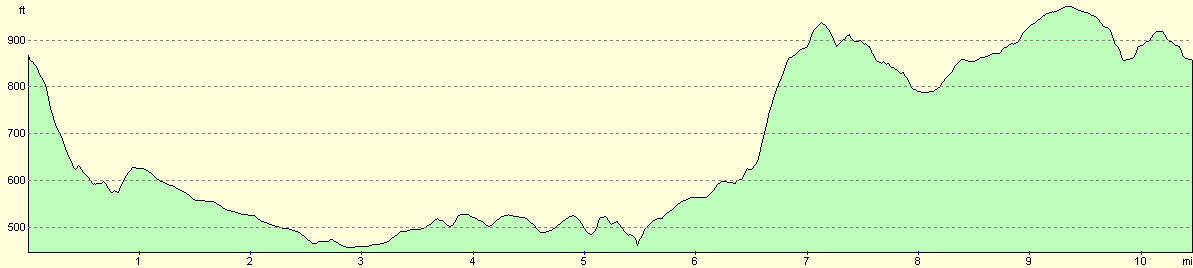
For more information on profiles, ascents and descents, see this page
Disclaimer
Please note that I take no responsibility for anything that may happen when following these directions. If you intend to follow this route, then please use the relevant maps and check the route out before you go out. As always when walking, use common sense and you should be fine.
If you find any information on any of these routes that is inaccurate, or you wish to add anything, then please email me.
All images on this site are © of the author. Any reproduction, retransmissions, or republication of all or part of any document found on this site is expressly prohibited, unless the author has explicitly granted its prior written consent to so reproduce, retransmit, or republish the material. All other rights reserved.
Although this site includes links providing convenient direct access to other Internet sites, I do not endorse, approve, certify or make warranties or representations as to the accuracy of the information on these sites.
And finally, enjoy your walking!
Nearby walks
| # | Title | Walk length (miles) |
|---|---|---|
| 74 | Wooton Rivers to Kintbury | 16.4 |
| 75 | Kintbury to Newbury | 9.3 |
| 99 | Newbury to Reading | 19.6 |
|
|

|